Bassin de Gotland
Le bassin de Gotland est le grand bassin central de la mer Baltique, situé entre la Suède et les pays baltes. Il est subdivisé entre Gdansk Deep (ou bassin de Gdańsk)[1] - [2], le bassin du Gotland occidental et le bassin du Gotland oriental. Dans le bassin du Gotland oriental se trouve le Gotland Deep (249 mètres de profondeur) qui est un bassin anoxique. Le bassin occidental du Gotland contient Landsort Deep, qui est l’endroit le plus profond de la mer Baltique (459 mètres de profondeur).
| Bassin de Gotland | |
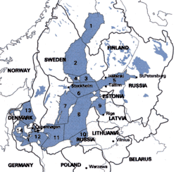
 Le bassin de Gotland est marqué par les numéros 7, 8 et 10 sur cette carte de l’environnement marin de la région | |
| Géographie physique | |
|---|---|
| Profondeur | |
| · Maximale | 459 m |
Les sédiments du bassin de Gotland sont importants pour l’étude des changements climatiques dans le nord de l’Europe au cours des 5 000 dernières années.
Notes et références
- (en) Cet article est partiellement ou en totalité issu de l’article de Wikipédia en anglais intitulé « Gotland Basin » (voir la liste des auteurs).
- (en) Matti Leppäranta et Kai Myrberg, Physical Oceanography of the Baltic Sea, Springer Science & Business Media, (ISBN 978-3-540-79703-6, lire en ligne), p. 145.
- (en) Jacek Bełdowski, Robert Been et Eyup Kuntay Turmus, Towards the Monitoring of Dumped Munitions Threat (MODUM): A Study of Chemical Munitions Dumpsites in the Baltic Sea, Springer Netherlands, (ISBN 978-94-024-1153-9, lire en ligne), p. 199.
Bibliographie
- Emeis, K.C., Neumann, T., Endler, R., Struck, U., Kunzendorf, H. et Christiansen, C., « Geochemical records of sediments in the Gotland Basin - products of sediment dynamics in a not so stagnant basin? », Applied Geochemistry, vol. 13, no 3, , p. 349-358.
- Hille, Sven, Nausch, Gunther et Leipe, Thomas, « Sedimentary deposition and reflux of phosphorus (P) in the Eastern Gotland Basin and their coupling with P concentrations in the water column », Oceanologia, vol. 4, no 47, , p. 663-679 (lire en ligne).
Liens externes
- (ru) Žurbas, V.M. et Paka, V.T., « Čislennoe modelirovanie rasprostraneniâ solenyh vod v Vostočnom Gotlandskom bassejne Baltiki posle bol'šsogo zatoka severomorskih vod », Meteorologiâ i gidrologiâ, no 9, , p. 70-81 (ISSN 0130-2906, lire en ligne).
Cet article est issu de wikipedia. Text licence: CC BY-SA 4.0, Des conditions supplémentaires peuvent s’appliquer aux fichiers multimédias.