Arbinda (département)
Arbinda est un département et une commune rurale du Burkina Faso, situé dans la province du Soum et la région du Sahel. En 2012, le département comptait 91 020 habitants.
| Arbinda | |||
| Administration | |||
|---|---|---|---|
| Pays | |||
| Région | Sahel | ||
| Province | Soum | ||
| Statut | Département Commune rurale |
||
| Subdivisions | 43 villages | ||
| Chef-lieu | Arbinda | ||
| Conseillers municipaux Mandat |
87 (2012-) |
||
| Démographie | |||
| Population | 91 020 hab. (2012) | ||
| Géographie | |||
| Coordonnées | 14° 06′ 00″ nord, 1° 37′ 59″ ouest | ||
| Divers | |||
| Fuseau horaire | UTC +0 | ||
| Indicatif téléphonique | +226
|
||
| Localisation | |||
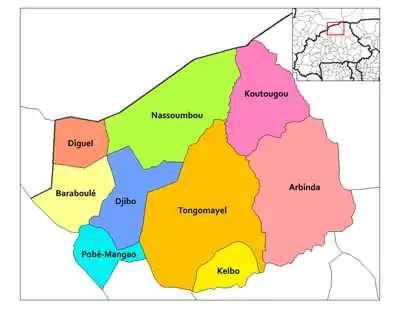
 Carte des départements du Soum. | |||
| Géolocalisation sur la carte : Burkina Faso
Géolocalisation sur la carte : Burkina Faso
| |||
Villages
Le département comprend un village chef-lieu (populations actualisées en 2012) :
et 42 autres villages :
- Aladjou (1 966 habitants)
- Arba-Débéré (1 230 habitants)
- Arra (2 925 habitants)
- Bamguel-Baguel (130 habitants)
- Belgou (2 674 habitants)
- Belhouro (2 909 habitants)
- Bossey (1 534 habitants)
- Boulikessi (916 habitants)
- Dalla (1 400 habitants)
- Dampéla (1 426 habitants)
- Dandio (642 habitants)
- Demtou (1 852 habitants)
- Djamkolga (1 148 habitants)
- Djika (4 510 habitants)
- Foubé (841 habitants)
- Gaïk-Goata (3 157 habitants)
- Gaselnaye (2 234 habitants)
- Gasséliki (3 767 habitants)
- Gorel (3 432 habitants)
- Gorguel (855 habitants)
- Irakoulga (1 275 habitants)
- Katté (1 283 habitants)
- Kioké (1 525 habitants)
- Kougri-Koulga (2 095 habitants)
- Kouilpagré (1 430 habitants)
- Liki (3 962 habitants)
- Lilgomdé (4 105 habitants)
- Madoudji (2 130 habitants)
- Niafo (2 601 habitants)
- Oualdéguédé (1 741 habitants)
- Ouilao (328 habitants)
- Oulf-Alpha (1 748 habitants)
- Palal-Sambo (2 499 habitants)
- Pelhouté (2 601 habitants)
- Pem (568 habitants)
- Pételdiré (520 habitants)
- Pételkotia (1 081 habitants)
- Sanga (1 646 habitants)
- Sikiré (3 206 habitants)
- Sirgné (669 habitants)
- Wérapoli (892 habitants)
- Yalanga (3 777 habitants)
Notes et références
- « Région du Sahel », sur www.inforoute-communale.gov.bf (consulté le )
Bibliographie
- Yves Urvoy, « Gravures rupestres dans l'Aribinda (Boucle du Niger) », Journal de la Société des Africanistes, 1941, Vol. 11, p. 1-5, [lire en ligne].
Cet article est issu de wikipedia. Text licence: CC BY-SA 4.0, Des conditions supplémentaires peuvent s’appliquer aux fichiers multimédias.

