Yargatenga (département)
Le Yargatenga est un département et une commune rurale de la province du Koulpélogo, situé dans la région du Centre-Est au Burkina Faso.
| Yargatenga | |||
| Administration | |||
|---|---|---|---|
| Pays | |||
| Région | Centre-Est | ||
| Province | Koulpélogo | ||
| Statut | Département Commune rurale |
||
| Subdivisions | 18 villages | ||
| Chef-lieu | Yargatenga | ||
| Conseillers municipaux Mandat |
37 (2012-) |
||
| Démographie | |||
| Population | 40 987 hab. (2012) | ||
| Géographie | |||
| Coordonnées | 11° 10′ 08″ nord, 0° 00′ 22″ est | ||
| Divers | |||
| Fuseau horaire | UTC +0 | ||
| Indicatif téléphonique | +226
|
||
| Localisation | |||
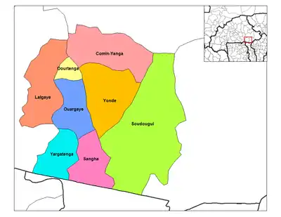
 Carte des départements de la province du Koulpélogo | |||
| Géolocalisation sur la carte : Burkina Faso
Géolocalisation sur la carte : Burkina Faso
| |||
| Liens | |||
| Site web | commune-yargatenga.org | ||
Géographie
Démographie
En 2012, le département comptait 40 987 habitants.
Villages
Le département et la commune rurale de Yargatenga est composé administrativement de dix-huit villages, dont le village chef-lieu homonyme :
- Bama (881 habitants)
- Bessémé (789 habitants)
- Bilemtenga (2 316 habitants)
- Bougla-Kino ou Bou (802 habitants)
- Cinkansé (10 913 habitants)
- Dirihoré (1 202 habitants)
- Doukbolé (1 091 habitants)
- Hornogo (1 465 habitants)
- Kampoaga (1 917 habitants)
- Kiniwaga (767 habitants)
- Kiongo (1 453 habitants)
- Métémété (1 484 habitants)
- Sibtenga (906 habitants)
- Tounougou-Toné (1 660 habitants)
- Waongo (4 179 habitants)
- Yargatenga (4 395 habitants), chef-lieu
- Yoyo (2 666 habitants)
- Zoaga (2 101 habitants)
Cet article est issu de wikipedia. Text licence: CC BY-SA 4.0, Des conditions supplémentaires peuvent s’appliquer aux fichiers multimédias.

