Stoczek (gmina)
La gmina Stoczek est un district administratif situé en milieu rural, dans la Węgrów en Voïvodie de Mazovie, dans le centre-est de la Pologne.
| Gmina Stoczek | ||||
 Héraldique |
||||
| Administration | ||||
|---|---|---|---|---|
| Pays | ||||
| Voïvodie (Région) |
Mazovie | |||
| Powiat (District) |
Węgrów | |||
| Siège | Stoczek | |||
| Plaque d'immatriculation | WWE | |||
| Démographie | ||||
| Population | 5 267 hab. (2006) | |||
| Densité | 36 hab./km2 | |||
| Géographie | ||||
| Coordonnées | 52° 33′ 00″ nord, 21° 55′ 00″ est | |||
| Superficie | 14 431 ha = 144,31 km2 | |||
| Localisation | ||||
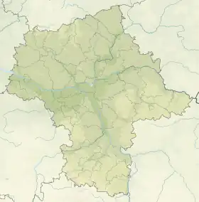
| Géolocalisation sur la carte : Voïvodie de Mazovie
Géolocalisation sur la carte : Voïvodie de Mazovie
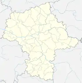
Géolocalisation sur la carte : Pologne
| ||||
| Liens | ||||
| Site web | www.stoczek.net.pl | |||
Son siège administratif (chef-lieu) est le village de Stoczek, qui se situe environ 18 km au nord-ouest de Węgrów (siège de la powiat) et 70 km au nord-est de Varsovie (capitale de la Pologne).
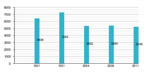
La gmina couvre une superficie de 144,31 km2 pour une population de 5 267 habitants[1] en 2006.
Géographie
La Gmina de Stoczek comprend les villages de :
_location_map.png.webp)
Plan de la gmina
Structure du terrain
D'après les données de 2002, la superficie de la commune de Szydłowiec est de 144,31 km2, répartis comme telle :
- terres agricoles : 57 %
- forêts : 38 %
La commune représente 11,84 % de la superficie du powiat.
Démographie
| Nom du village | Superficie en km² | Nombre d'habitants au 31.12.2008[2] |
|---|---|---|
| Błotki | 1,5118 | 138 |
| Brzózka | 4,79018 | 178 |
| Drgicz | 8,5003 | 400 |
| Gajówka Wschodnia | 1,3579 | 33 |
| Gajówka Zachodnia | 3,472333 | 71 |
| Grabowiec | 3,9755 | 293 |
| Gruszczyno | 5,94545 | 111 |
| Grygrów | 2,5791 | 208 |
| Huta Gruszczyno | 1,0024 | 105 |
| Kalaty | 0,6992 | 19 |
| Kałęczyn | 2,50852 | 96 |
| Kazimierzów | 3,0024 | 13 |
| Kozołupy | 3,0951 | 126 |
| Majdan | 4,334393 | 237 |
| Marianów | 2,1184 | 27 |
| Miednik | 21,841971 | 47 |
| Mrozowa Wola | 5,704679 | 570 |
| Nowe Lipki | 7,14322 | 71 |
| Polkowo | 8,084046 | 127 |
| Stare Lipki | 17,020889 | 328 |
| Stoczek | 8,98931 | 910 |
| Topór + Księżyzna | 9,759393 | 534 + 31 |
| Wieliczna | 6,13253 | 223 |
| Zgrzebichy | 6,047686 | 240 |
| Żulin | 4,693100 | 254 |
| Total | 144,31 | 5390 |
Données du :
| Description | Total | Femmes | Hommes | |||
|---|---|---|---|---|---|---|
| Unité | Nombre | % | Nombre | % | Nombre | % |
| Population | 5 362 | 100 | 2 706 | 50,5 | 2 656 | 49,5 |
| Densité (hab./km²) | 37,2 | 18,8 | 18,4 | |||
Annexes
Liens internes
Références
- (en) « Area and Population in the Territorial Profile in 2012 », Głowny Urząd Statystyczny
- « stoczek.net.pl/gmina/?podzial-… »(Archive.org • Wikiwix • Archive.is • Google • Que faire ?).
Liens externes
Cet article est issu de wikipedia. Text licence: CC BY-SA 4.0, Des conditions supplémentaires peuvent s’appliquer aux fichiers multimédias.