Registre national des lieux historiques dans le comté de Riverside
Ceci est la liste des lieux historiques inscrits sur le registre national dans le comté de Riverside en Californie.
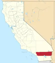
Localisation du comté de Riverside en Californie
C'est censé être une liste exhaustive des propriétés et des districts des lieux historiques du registre national dans le comté de Riverside, en Californie. Les coordonnées de latitude et longitude sont fournies pour la plupart des propriétés et les districts du registre national ; ces localisations peuvent être aperçus sur Google Map.
Il y a 87 propriétés et districts répertoriés sur le registre national dans le comté, dont deux monuments historiques nationaux.
Liste actuelle
| Position | ID | Type | Nom | Localisation | Ville | Date d'inscription | Image | Coordonnées | Description | |
|---|---|---|---|---|---|---|---|---|---|---|
| 1 | 80000831 | NRHP | Administration Building, Sherman Institute (en) | 9010 Magnolia Ave. | Riverside | 33° 55′ 30″ nord, 117° 26′ 13″ ouest | ||||
| 2 | 16000093 | NRHP | Dr. Franz Alexander House (en) | 1011 W. Cielo Dr. | Palm Springs | 33° 50′ 44″ nord, 116° 33′ 35″ ouest | ||||
| 3 | 78000736 | NRHP | All Souls Universalist Church (en) | 3657 Lemon St. | Riverside |  |
33° 58′ 56″ nord, 117° 22′ 14″ ouest | |||
| 4 | 73000422 | HD | Andreas Canyon (en) | Adresse restreinte | Palm Springs | |||||
| 5 | 03000121 | NRHP | Archeological Sites CA-RIV-504 and CA-RIV-773 (en) | Adresse restreinte | Blythe | |||||
| 6 | 93000668 | NRHP | Arlington Branch Library and Fire Hall (en) | 9556 Magnolia Ave. | Riverside |  |
33° 55′ 11″ nord, 117° 26′ 48″ ouest | |||
| 7 | 91002032 | NRHP | Armory Hall (en) | 252 N. Main St. | Lake Elsinore |  |
33° 40′ 15″ nord, 117° 19′ 32″ ouest | |||
| 8 | 75000173 | NRHP | Barrage Barker | SE of Twentynine Palms in Joshua Tree National Park | Twentynine Palms | 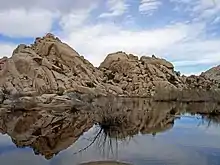 |
34° 01′ 52″ nord, 116° 08′ 39″ ouest | |||
| 9 | 100002238 | NRHP | Miles C. Bates House (en) | 73697 Santa Rosa Way | Palm Desert |  |
33° 43′ 40″ nord, 116° 22′ 45″ ouest | |||
| 10 | 75000452 | HD | Blythe Intaglios | Adresse restreinte | Blythe | .jpg.webp) |
||||
| 11 | 76000509 | HD | Buttercup Farms Pictograph (en) | Adresse restreinte | Perris | |||||
| 12 | 11000942 | NRHP | Cabot's Old Indian Pueblo Museum (en) | 67-616 E. Desert View Ave. | Desert Hot Springs | date=2012-3-2 |  |
33° 57′ 29″ nord, 116° 28′ 56″ ouest | ||
| 13 | 15000635 | NRHP | Carey House (en) | 651 W. Via Escuela | Palm Springs |  |
33° 50′ 55″ nord, 116° 33′ 18″ ouest | |||
| 14 | 77000324 | NRHP | Andrew Carnegie Library (en) | 8th and Main Sts. | Corona | 33° 52′ 23″ nord, 117° 33′ 56″ ouest | Démoli en 1978 | |||
| 15 | 99000895 | NRHP | William Childs House (en) | 1151 Monte Vista Dr. | Riverside | 33° 57′ 32″ nord, 117° 20′ 11″ ouest | ||||
| 16 | 90000151 | NRHP | Chinatown | Brockton and Tequesquite Aves. | Riverside | 33° 58′ 35″ nord, 117° 23′ 05″ ouest | ||||
| 17 | 72000247 | NRHP | Coachella Valley Fish Traps (en) | Adresse restreinte | Valerie (en) | |||||
| 18 | 16000885 | NRHP | Coachella Valley Savings No. 2 (en) | 499 S. Palm Canyon Dr. | Palm Springs |  |
33° 48′ 58″ nord, 116° 32′ 49″ ouest | |||
| 19 | 100001906 | NRHP | Community Settlement House (en) | 4366 Bermuda Ave. | Riverside | 33° 58′ 15″ nord, 117° 21′ 47″ ouest | ||||
| 20 | 98001286 | NRHP | Corn Springs (en) | Adresse restreinte | Desert Center | |||||
| 21 | 05000772 | NRHP | Corona High School (en) | 815 W. 6th St. | Corona | 33° 52′ 35″ nord, 117° 34′ 32″ ouest | ||||
| 22 | 75000453 | NRHP | Crescent Bathhouse (en) | 201 W. Graham Ave. | Lake Elsinore |  |
33° 40′ 09″ nord, 117° 19′ 47″ ouest | |||
| 23 | 76000216 | HD | Desert Queen Mine | S of Twentynine Palms in Joshua Tree National Park | Twentynine Palms |  |
34° 01′ 26″ nord, 116° 04′ 09″ ouest | |||
| 24 | 16000886 | NRHP | Edris House (en) | 1030 W. Cielo Dr. | Palm Springs | 33° 50′ 45″ nord, 116° 33′ 40″ ouest | ||||
| 25 | 16000169 | NRHP | Arthur Elrod House | 2175 Southridge Dr. | Palm Springs | 33° 47′ 36″ nord, 116° 30′ 39″ ouest | ||||
| 26 | 01001178 | NRHP | Estudillo Mansion (en) | 150 S. Dillon | San Jacinto |  |
33° 46′ 51″ nord, 116° 58′ 02″ ouest | |||
| 27 | 78000737 | NRHP | Federal Post Office (en) | 3720 Orange St. | Riverside |  |
33° 58′ 55″ nord, 117° 22′ 18″ ouest | |||
| 28 | 15000636 | NRHP | Fire Station No. 1 (en) | 277 N. Indian Canyon Dr. | Palm Springs |  |
33° 49′ 34″ nord, 116° 32′ 45″ ouest | |||
| 29 | 16000357 | NRHP | First Church of Christ, Scientist (en) | 605 S. Riverside Dr. | Palm Springs |  |
33° 48′ 37″ nord, 116° 32′ 33″ ouest | |||
| 30 | 92001250 | NRHP | First Church of Christ, Scientist (en) | 3606 Lemon St. | Riverside |  |
33° 58′ 57″ nord, 117° 22′ 11″ ouest | |||
| 31 | 97000297 | NRHP | First Congregational Church of Riverside (en) | 3504 Mission Inn Ave. | Riverside |  |
33° 58′ 54″ nord, 117° 22′ 16″ ouest | |||
| 32 | 15000637 | NRHP | Frey House II | 686 Palisades Dr. | Palm Springs | .jpg.webp) |
33° 49′ 24″ nord, 116° 33′ 11″ ouest | |||
| 33 | 03000533 | HD | Galleano Winery (en) | 4231 Wineville Rd. | Mira Loma |  |
34° 00′ 40″ nord, 117° 32′ 29″ ouest | |||
| 34 | 99001593 | HD | Rocco Garbani Homestead (en) | 33555 Holland Rd. | Winchester | 33° 39′ 34″ nord, 117° 04′ 24″ ouest | ||||
| 35 | 76000508 | HD | Gilman Ranch (en) | 1937 W. Gilman St. | Banning |  |
33° 56′ 15″ nord, 116° 53′ 54″ ouest | |||
| 36 | 11000432 | HD | Grand Boulevard Historic District (en) | Grand Boulevard | Corona |  |
33° 52′ 09″ nord, 117° 34′ 02″ ouest | |||
| 37 | 16000635 | NRHP | Hamrick House (en) | 875 W. Chino Canyon Rd. | Palm Springs | 33° 50′ 48″ nord, 116° 33′ 30″ ouest | ||||
| 38 | 77000325 | NHL | Harada House (en) | 3356 Lemon St. | Riverside |  |
33° 59′ 06″ nord, 117° 22′ 05″ ouest | |||
| 39 | 73000423 | NRHP | Heritage House (en) | 8193 Magnolia Ave. | Riverside |  |
33° 56′ 05″ nord, 117° 25′ 20″ ouest | |||
| 40 | 100001663 | NRHP | Thomas Jefferson Elementary School (en) | 1040 S. Vicentia Ave. | Corona | 33° 52′ 19″ nord, 117° 34′ 33″ ouest | ||||
| 41 | 79000519 | NRHP | Cornelius Jensen Ranch (en) | 4350 Riverview Dr | Rubidoux | 33° 59′ 34″ nord, 117° 25′ 01″ ouest | ||||
| 42 | 16000887 | NRHP | Kenaston House (en) | 39767 Desert Sun Dr. | Rancho Mirage |  |
33° 45′ 34″ nord, 116° 25′ 05″ ouest | |||
| 43 | 15000638 | NRHP | Kocher-Samson Building (en) | 766 N. Palm Canyon Dr. | Palm Springs |  |
33° 50′ 01″ nord, 116° 32′ 48″ ouest | |||
| 44 | 16000888 | NRHP | Koerner House (en) | 1275 S. Calle de Maria | Palm Springs | 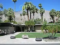 |
33° 48′ 22″ nord, 116° 31′ 57″ ouest | |||
| 45 | 00000033 | HD | Lake Norconian Club (en) | Junction of Fifth and Western Ave. | Norco | 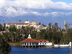 |
33° 55′ 30″ nord, 117° 34′ 06″ ouest | |||
| 46 | 03000118 | NRHP | Gus Lederer Site (en) | Adresse restreinte | Desert Center | |||||
| 47 | 15000639 | NRHP | Loewy House (en) | 600 Panorama Rd. | Palm Springs | 33° 50′ 43″ nord, 116° 33′ 16″ ouest | ||||
| 48 | 14000851 | NRHP | Luiseno Ancestral Origin Landscape (en) | Adresse restreinte | Temecula | |||||
| 49 | 94001420 | HD | District historique de terrain de March | Eschscholtzia Ave., March Air Force Base | Riverside | date_extra= | 33° 53′ 59″ nord, 117° 15′ 17″ ouest |  | ||
| 50 | 99001471 | NRHP | Martinez Canyon Rockhouse (en) | BLM, Palm Springs-South Coast Resource Area | North Palm Springs (en) |  |
33° 30′ 20″ nord, 116° 19′ 31″ ouest | |||
| 51 | 73000425 | HD | Martinez Historical District (en) | Off SR 86 | Réserve indienne de Torres-Martinez (en) | 33° 33′ 46″ nord, 116° 09′ 12″ ouest | ||||
| 52 | 80000832 | NRHP | Masonic Temple (en) | 3650 11th St. | Riverside | 33° 58′ 43″ nord, 117° 22′ 30″ ouest | ||||
| 53 | 82002226 | NRHP | McCoy Spring Archeological Site (en) | Adresse restreinte | Blythe | |||||
| 54 | 93000549 | HD | Mission Court Bungalows (en) | 3355-3373 Second St. and 3354-3362 First St. | Riverside | 33° 59′ 12″ nord, 117° 21′ 55″ ouest | ||||
| 55 | 71000173 | NHL | Mission Inn | 3649 7th St. | Riverside | 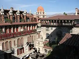 |
33° 59′ 00″ nord, 117° 22′ 18″ ouest | |||
| 56 | 13000416 | HD | Mount San Jacinto State Park Historic District (en) | 25905 CA 243 | Idyllwild (en) | 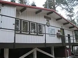 |
33° 45′ 01″ nord, 116° 42′ 52″ ouest | |||
| 57 | 73000424 | HD | Murrieta Creek Archeological Area (en) | Adresse restreinte | Temecula | |||||
| 58 | 81000165 | HD | North Chuckwalla Mountain Quarry District (en) | Adresse restreinte | Desert Center | |||||
| 59 | 81000166 | HD | North Chuckwalla Mountains Petroglyph District Ca-Riv 1383 (en) | Adresse restreinte | Desert Center | |||||
| 60 | 15000640 | NRHP | North Shore Yacht Club (en) | 99-155 Sea View Dr. | Mecca |  |
33° 31′ 10″ nord, 115° 56′ 14″ ouest | |||
| 61 | 10001123 | NRHP | Thomas O'Donnell House (en) | 447 Alejo Rd. | Palm Springs | 33° 49′ 49″ nord, 116° 33′ 09″ ouest | ||||
| 62 | 82002227 | NRHP | Old YWCA Building (en) | 3425 Mission Inn Avenue | Riverside |  |
33° 58′ 54″ nord, 117° 22′ 14″ ouest | |||
| 63 | 16000889 | NRHP | Palm Springs Aerial Tramway Mountain Station (en) | 1 Tram Way | Environs de Idyllwild (en) | .jpg.webp) |
33° 48′ 47″ nord, 116° 38′ 19″ ouest | |||
| 64 | 15000641 | NRHP | Palm Springs City Hall (en) | 3200 E. Tahquitz Canyon Way | Palm Springs |  |
33° 49′ 25″ nord, 116° 30′ 42″ ouest | |||
| 65 | 16000890 | NRHP | Musée de Palm Springs Desert | 101 Museum Dr. | Palm Springs | 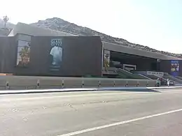 |
33° 49′ 27″ nord, 116° 33′ 00″ ouest | |||
| 66 | 15000642 | NRHP | Station de la valle du tramway de Palm Springs | 1 Tram Way | Palm Springs |  |
33° 50′ 15″ nord, 116° 36′ 50″ ouest | |||
| 67 | 16000891 | NRHP | Palm Springs Unified School District Educational Administrative Center (en) | 333 S. Farrell Dr. | Palm Springs |  |
33° 49′ 08″ nord, 116° 31′ 06″ ouest | |||
| 68 | 16000173 | NRHP | Pearlman Mountain Cabin (en) | 52820 Middleridge Dr. | Idyllwild (en) | 33° 43′ 50″ nord, 116° 44′ 27″ ouest | ||||
| 69 | 94000819 | NRHP | Perris Depot (en) | 120 W. Fourth St. | Perris |  |
33° 46′ 58″ nord, 117° 13′ 46″ ouest | |||
| 70 | 78000738 | NRHP | Riverside Municipal Auditorium and Soldiers' Memorial Building (en) | 3485 7th St. | Riverside |  |
33° 58′ 55″ nord, 117° 22′ 12″ ouest | |||
| 71 | 80000833 | NRHP | Riverside-Arlington Heights Fruit Exchange (en) | 3391 7th St. | Riverside | 33° 58′ 52″ nord, 117° 22′ 10″ ouest | ||||
| 72 | 75000175 | HD | Ryan House and Lost Horse Well | S of Twentynine Palms in Joshua Tree National Park | Twentynine Palms | 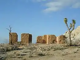 |
33° 59′ 06″ nord, 116° 08′ 52″ ouest | |||
| 73 | 77000326 | NRHP | San Pedro, Los Angeles, & Salt Lake RR Depot (en) | 3751 Vine St. | Riverside |  |
33° 58′ 45″ nord, 117° 21′ 59″ ouest | |||
| 74 | 00001646 | NRHP | San Timoteo Canyon Schoolhouse (en) | 31985 San Timoteo Canyon Rd. | Redlands |  |
33° 58′ 33″ nord, 117° 06′ 10″ ouest | |||
| 75 | 16000892 | NRHP | Santa Fe Federal Savings and Loan Association (en) | 300 S. Palm Canyon Dr. | Palm Springs |  |
33° 49′ 09″ nord, 116° 32′ 48″ ouest | |||
| 76 | 15000643 | NRHP | Sieroty House (en) | 695 E. Vereda Sur | Palm Springs |  |
33° 50′ 19″ nord, 116° 32′ 22″ ouest | |||
| 77 | 80000834 | NRHP | M. H. Simon's Undertaking Chapel (en) | 3610 11th St. | Riverside |  |
33° 58′ 43″ nord, 117° 22′ 29″ ouest | |||
| 78 | 16000893 | NRHP | Maison de Frank Sinatra | 1145 E. Via Colusa Rd. | Palm Springs |  |
33° 49′ 52″ nord, 116° 32′ 01″ ouest | |||
| 79 | 92001384 | NRHP | Southern Hotel (en) | 445 S. D St. | Perris | 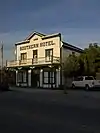 |
33° 46′ 55″ nord, 117° 13′ 42″ ouest | |||
| 80 | 12000125 | NRHP | Steel Development House Number 2 (en) | 3125 N. Sunny View Dr. | Riverside | date=2012-3-20 | 33° 51′ 30″ nord, 116° 32′ 40″ ouest | |||
| 81 | 86000732 | NRHP | Sutherland Fruit Company (en) | 3191 Seventh St. | Riverside | 33° 58′ 50″ nord, 117° 21′ 59″ ouest | ||||
| 82 | 72000246 | NRHP | Tahquitz Canyon (en) | 500 West Mesquite | Palm Springs | 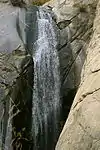 |
33° 48′ 31″ nord, 116° 33′ 02″ ouest | |||
| 83 | 15000645 | NRHP | Tramway Gas Station (en) | 2901 N. Palm Canyon Dr. | Palm Springs | 33° 51′ 30″ nord, 116° 33′ 29″ ouest | Actuellement le centre des visiteurs de Palm Springs | |||
| 84 | 93000547 | NRHP | University Heights Junior High School (en) | 2060 University Ave. | Riverside | 33° 58′ 30″ nord, 117° 21′ 20″ ouest | ||||
| 85 | 00001267 | NRHP | Victoria Avenue (en) | Victoria Ave., from Arlington Ave. to Boundary Ln. | Riverside |  |
33° 55′ 33″ nord, 117° 23′ 57″ ouest | |||
| 86 | 16000894 | NRHP | E. Stewart and Mari Williams House (en) | Address restricted | Palm Springs | |||||
| 87 | 88002014 | NRHP | Woman's Improvement Club Clubhouse (en) | 1101 S. Main St. | Corona |  |
33° 52′ 12″ nord, 117° 33′ 58″ ouest |
Voir aussi
- Liste des National Historic Landmarks de Californie
- Liste des lieux historiques inscrits sur le registre national en Californie
- Monuments historiques de Californie dans le comté de Riverside (en)
Liens externes
- NoeHill Voyage en Californie: Sites Historiquesh dans le Comtéc de Riverside pour une liste des monuments NRHP et de Californie
Références
Cet article est issu de wikipedia. Text licence: CC BY-SA 4.0, Des conditions supplémentaires peuvent s’appliquer aux fichiers multimédias.