Liste des volcans de Papouasie-Nouvelle-Guinée
Cet article recense les volcans de Papouasie-Nouvelle-Guinée.
Liste
Nouvelle-Guinée
| Nom | Forme | Altitude | Dernière éruption | Coordonnées |
|---|---|---|---|---|
| Crater Mountain | Stratovolcan | 3 233 | ? | 6° 35′ S, 145° 05′ E |
| Doma | Stratovolcan | 3 568 | ? | 5° 54′ S, 143° 09′ E |
| Mont Giluwe | ? | 4 368 | ~ 220 000 ans | 6° 03′ S, 143° 53′ E |
| Hagen | ? | 3 778 | ~ 210 000 ans | 5° 45′ S, 144° 02′ E |
| Chaîne des Hydrographes | Stratovolcan | 1 915 | ? | 9° 00′ S, 148° 22′ E |
| Koranga | Maar | 1 500 | ? | 7° 20′ S, 146° 42′ E |
| Lamington | Stratovolcan | 1 680 | 1956 | 8° 57′ S, 148° 09′ E |
| Madilogo | Cône pyroclastique | 850 | ? | 9° 12′ S, 147° 34′ E |
| Managlase | Champ volcanique | 1 342 | ? | 9° 05′ S, 148° 20′ E |
| Musa River | Champ hydrothermal | 808 | ? | 9° 18′ S, 148° 08′ E |
| Sessagara | Cônes pyroclastiques | 370 | ? | 9° 29′ S, 149° 08′ E |
| Victory | Stratovolcan | 1 925 | 1935 | 9° 12′ S, 149° 04′ E |
| Waiowa | Cône pyroclastique | 640 | 1944 | 9° 34′ S, 149° 04′ E |
| Yelia | Stratovolcan | 3 384 | ? | 7° 03′ S, 145° 51′ E |
Îles de l'Amirauté
| Nom | Forme | Altitude | Dernière éruption | Coordonnées |
|---|---|---|---|---|
| Baluan | Stratovolcan | 254 | Holocène | 2° 34′ S, 147° 17′ E |
| Détroit de Saint-Andrew | Volcan complexe | 270 | 1957 | 2° 23′ S, 147° 21′ E |
Bougainville
| Nom | Forme | Altitude | Dernière éruption | Coordonnées |
|---|---|---|---|---|
| Bagana | Cône de lave | 1 855 | 2006 | 6° 08′ S, 155° 12′ E |
| Balbi | Stratovolcan | 2 715 | Holocène | 5° 55′ S, 154° 59′ E |
| Billy Mitchell | Bouclier pyroclastique | 1 544 | 1580 | 6° 06′ S, 155° 13′ E |
| Loloru | Bouclier pyroclastique | 1 887 | 1050 av. J.-C. | 6° 31′ S, 155° 37′ E |
| Takuan | Complexe volcanique | 2 210 | Holocène | 6° 27′ S, 155° 36′ E |
| Tore | Cône de lave | 2 200 | Holocène | 5° 50′ S, 154° 56′ E |
Îles d'Entrecasteaux
| Nom | Forme | Altitude | Dernière éruption | Coordonnées |
|---|---|---|---|---|
| Détroit de Dawson | Champ volcanique | 500 | 1350 | 9° 37′ S, 150° 53′ E |
| Goodenough | Champ volcanique | 220 | Holocène | 9° 29′ S, 150° 21′ E |
| Iamalele | Dômes de lave | 200 | Holocène | 9° 31′ S, 150° 32′ E |
Nouvelle-Bretagne
| Nom | Forme | Altitude | Dernière éruption | Coordonnées |
|---|---|---|---|---|
| Bamus | Stratovolcan | 2 248 | 1886 | 5° 12′ S, 151° 14′ E |
| Bola | Stratovolcan | 1 155 | Holocène | 5° 09′ S, 150° 02′ E |
| Dakataua | Caldeira | 400 | 1895 | 5° 03′ S, 150° 06′ E |
| Garbuna | Stratovolcans | 564 | ? | 5° 27′ S, 150° 02′ E |
| Garove | Stratovolcan | 368 | Holocène | 4° 42′ S, 149° 30′ E |
| Garua | Champ volcanique | 565 | ? | 5° 18′ S, 150° 04′ E |
| Hargy | Stratovolcan | 1 148 | 950 | 5° 20′ S, 151° 06′ E |
| Langila | Volcan complexe | 1 330 | 2021 | 5° 32′ S, 148° 25′ E |
| Lolo | Stratovolcan | 805 | ? | 5° 28′ S, 150° 30′ E |
| Lolobau | Caldeira | 858 | 1912 | 4° 55′ S, 151° 09′ E |
| Mundua | Volcan complexe | 179 | Holocène | 4° 38′ S, 149° 21′ E |
| Narage | ? | 307 | Pleistocene | 4° 33′ S, 149° 08′ E |
| Pago | Caldeira | 742 | 2003 | 5° 35′ S, 150° 31′ E |
| Rabaul | Bouclier pyroclastique | 688 | 2006 | 4° 16′ S, 152° 12′ E |
| Sulu | Stratovolcans | 610 | ? | 5° 30′ S, 150° 57′ E |
| Tavui | Caldeira | 200 | 5150 av. J.-C. | 4° 07′ S, 152° 12′ E |
| Ulawun | Stratovolcan | 2 334 | 2005 | 5° 03′ S, 151° 20′ E |
Nouvelle-Irlande
| Nom | Forme | Altitude | Dernière éruption | Coordonnées |
|---|---|---|---|---|
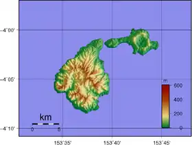
| Ambitle | Stratovolcan | 450 | 350 av. J.-C. | 4° 05′ S, 153° 39′ E |
| Lihir | Complexe volcanique | 700 | Holocène | 3° 08′ S, 152° 39′ E |
Autres îles
| Nom | Forme | Altitude | Dernière éruption | Coordonnées |
|---|---|---|---|---|
| Bam | Stratovolcan | 685 | 1960 | 3° 37′ S, 144° 49′ E |
| Blup Blup | Stratovolcan | 402 | ? | 3° 30′ S, 144° 36′ E |
| Boisa | Stratovolcan | 240 | ? | 4° 00′ S, 144° 58′ E |
| Kadovar | Stratovolcan | 365 | 2018 | 3° 38′ S, 144° 38′ E |
| Karkar | Stratovolcan | 1 839 | 1979 | 4° 39′ S, 145° 58′ E |
| Long Island | Volcan complexe | 1 280 | 1993 | 5° 21′ S, 147° 07′ E |
| Manam | Stratovolcan | 1 807 | 2006 | 4° 05′ S, 145° 02′ E |
| Nouvelle-Hanovre | ? | ? | ? | 2° 30′ S, 150° 15′ E |
| Ritter | Stratovolcan | 140 | 1974 | 5° 31′ S, 148° 07′ E |
| Sakar | Stratovolcan | 992 | ? | 5° 25′ S, 148° 06′ E |
| Umboi | Volcan complexe | 1 548 | Holocène | 5° 35′ S, 147° 53′ E |
| Volcan sans nom | Volcan sous-marin | −1 300 | ? | 3° 02′ S, 147° 47′ E |
| Yomba | Volcan sous-marin ? | 0 | ? | 4° 54′ S, 146° 45′ E |
Annexes
Articles connexes
Liens externes
- Pour l'ensemble des points mentionnés sur cette page : voir sur OpenStreetMap (aide) ou télécharger au format KML (aide).
- (en) Volcanoes of Melanesia and Australia (Global Volcanism Program)
Cet article est issu de wikipedia. Text licence: CC BY-SA 4.0, Des conditions supplémentaires peuvent s’appliquer aux fichiers multimédias.