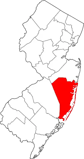
Comté d'Ocean
Le comté d'Ocean (en anglais Ocean County) est un comté situé à l'est de l'État de New Jersey, aux États-Unis. Le comté fait partie de l'agglomération new-yorkaise. Selon le recensement de 2020, il a 637 229 habitants.
| Comté d'Ocean (Ocean County) | |
 Drapeau du comté. | |
 Lever du soleil au Phare de Barnegat sur Long Beach Island | |
| Administration | |
|---|---|
| Pays | |
| État | |
| Chef-lieu | Toms River |
| Fondation | 1850 |
| Démographie | |
| Population | 637 229 hab. (2020) |
| Densité | 387 hab./km2 |
| Géographie | |
| Coordonnées | 39° 52′ nord, 74° 15′ ouest |
| Superficie | 164 800 ha = 1 648 km2 |
| Superficie eau | 72 400 ha = 724 km2 |
| Superficie totale | 237 200 ha = 2 372 km2 |
| Localisation | |
 Localisation dans le New Jersey. | |
Le comté est créé le à partir du comté de Monmouth[1]. Il doit son nom à l'Océan Atlantique, qu'il borde[2].
Comtés adjacents
- Comté de Monmouth (nord)
- Comté d'Atlantic (sud)
- Comté de Burlington (ouest)
Municipalités
.png.webp)
Carte des municipalités du comté.
- Barnegat Township (29)
- Barnegat Light (6)
- Bay Head (16)
- Beach Haven (2)
- Beachwood (12)
- Berkeley Township (26)
- Brick Township (23)
- Eagleswood Township (31)
- Harvey Cedars (5)
- Island Heights (10)
- Jackson Township (21)
- Lacey Township (27)
- Lakehurst (19)
- Lakewood Township (22)
- Lavallette (14)
- Little Egg Harbor Township (33)
- Long Beach Township (32)
- Manchester Township (25)
- Mantoloking (15)
- Ocean Township (28)
- Ocean Gate (9)
- Pine Beach (11)
- Plumsted Township (20)
- Point Pleasant (18)
- Point Pleasant Beach (17)
- Seaside Heights (8)
- Seaside Park (7)
- Ship Bottom (3)
- South Toms River (13)
- Stafford Township (30)
- Surf City (4)
- Toms River Township (24)
- Tuckerton (1)
- East Windsor Township (6)
- Ewing Township (11)
- Hamilton Township (8)
- Hightstown (5)
- Hopewell (1)
- Hopewell Township (12)
- Lawrence Township (10)
- Pennington (2)
- Princeton (3)
- Robbinsville Township (7)
- Trenton (4)
- West Windsor Township (9)
Politique
Le comté est un bastion du Parti républicain[3] - [4].
Démographie
| Historique des recensements | |||
| Ann. | Pop. | %± | |
|---|---|---|---|
| 1850 | 10 032 | — | |
| 1860 | 11 176 | ▲ +11,4 % | |
| 1870 | 13 628 | ▲ +21,94 % | |
| 1880 | 14 455 | ▲ +6,07 % | |
| 1890 | 15 974 | ▲ +10,51 % | |
| 1900 | 19 747 | ▲ +23,62 % | |
| 1910 | 21 318 | ▲ +7,96 % | |
| 1920 | 22 155 | ▲ +3,93 % | |
| 1930 | 33 069 | ▲ +49,26 % | |
| 1940 | 37 706 | ▲ +14,02 % | |
| 1950 | 56 622 | ▲ +50,17 % | |
| 1960 | 108 241 | ▲ +91,16 % | |
| 1970 | 208 470 | ▲ +92,6 % | |
| 1980 | 346 038 | ▲ +65,99 % | |
| 1990 | 433 203 | ▲ +25,19 % | |
| 2000 | 510 916 | ▲ +17,94 % | |
| 2010 | 576 567 | ▲ +12,85 % | |
| 2020 | 637 229 | ▲ +10,52 % | |
Notes et références
- (en) John P. Snyder, The Story of New Jersey's Civil Boundaries: 1606-1968, Trenton, Bureau of Geology and Topography, (lire en ligne), p. 201.
- (en) Federal Writers' Project, The Origin of New Jersey Place Names, Trenton, New Jersey Public Library Commission, (lire en ligne), p. 24
- (en) Chris Megerian, « Republican stronghold in Ocean County is key to Chris Christie's get-out-the-vote plan », sur nj.com, (consulté le ).
- (en) Micah Cohen, « In Blue New Jersey, Red Spots May Be Sign of the Past », sur fivethirtyeight.blogs.nytimes.com, (consulté le ).
Cet article est issu de wikipedia. Text licence: CC BY-SA 4.0, Des conditions supplémentaires peuvent s’appliquer aux fichiers multimédias.