Ship Bottom
Ship Bottom est une municipalité américaine située dans le comté d'Ocean au New Jersey.
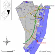
Ship Bottom
_between_4th_Street_and_5th_Street_in_Ship_Bottom%252C_Ocean_County%252C_New_Jersey.jpg.webp)
| Pays | |
|---|---|
| État | |
| Comté | |
| Superficie |
2,59 km2 () |
| Surface en eau |
28,73 % |
| Altitude |
1 m |
| Coordonnées |
39° 38′ 43″ N, 74° 10′ 59″ O |
| Population |
1 098 hab. () |
|---|---|
| Densité |
423,6 hab./km2 () |
| Statut |
|---|
| Fondation |
|---|
| Code postal |
08008 |
|---|---|
| Code FIPS |
34-67110 |
| GNIS | |
| Indicatif téléphonique |
609 |
| Site web |
(en) www.shipbottom.org |

Lors du recensement de 2010, sa population est de 1 156 habitants[1]. La municipalité s'étend sur 1,00 milles carrés (2,59 km2), dont 0,29 milles carrés (0,75 km2) d'étendues d'eau[1].
La ville devient un borough indépendant de Long Beach Township au printemps 1925, sous le nom de Ship Bottom-Beach Arlington. Elle adopte son nom actuel en 1947[2]. Il fait référence à une fillette sauvée d'un bateau (en anglais : ship) dont le fond (en anglais : bottom) était détruit[3].
Notes et références
- (en) Bureau du recensement des États-Unis, « Population, Housing Units, Area, and Density: 2010 - State -- Place and (in selected states) County Subdivision 2010 Census Summary File 1 », sur factfinder.census.gov (consulté le ).
- (en) John P. Snyder, The Story of New Jersey's Civil Boundaries: 1606-1968, Trenton, Bureau of Geology and Topography, (lire en ligne), p. 205.
- (en) Federal Writers' Project, The Origin of New Jersey Place Names, Trenton, New Jersey Public Library Commission, (lire en ligne), p. 29
Cet article est issu de wikipedia. Text licence: CC BY-SA 4.0, Des conditions supplémentaires peuvent s’appliquer aux fichiers multimédias.