Lhota (district de Prague-Est)
Lhota (auparavant : Lhota nad Labem, Lhota u Staré Boleslavi ou Lhota u Dřís) est une commune du district de Prague-Est, dans la région de Bohême-Centrale, en République tchèque. Sa population s'élevait à 483 habitants en 2020[1].
| Lhota | |
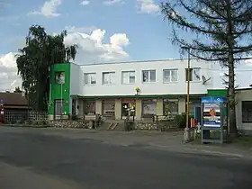
 Lhota : la mairie. | |
 |
 |
| Administration | |
|---|---|
| Pays | |
| Région | |
| District | Prague-Est |
| Région historique | Bohême |
| Maire | Radka Kratochvílová |
| Code postal | 277 14 |
| Indicatif téléphonique international | +(420) |
| Démographie | |
| Population | 483 hab. (2020) |
| Densité | 61 hab./km2 |
| Géographie | |
| Coordonnées | 50° 14′ 36″ nord, 14° 39′ 23″ est |
| Altitude | 172 m |
| Superficie | 796 ha = 7,96 km2 |
| Localisation | |
 | |
| Liens | |
| Site web | www.lhotanadlabem.cz |
Géographie
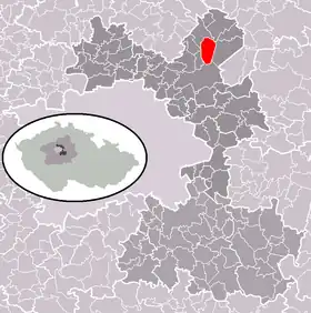
Lhota se trouve à 6 km au nord de Brandýs nad Labem-Stará Boleslav et à 24 km au nord-est du centre de Prague[2].
La commune est limitée par Dřísy au nord-ouest et au nord, par Sudovo Hlavno au nord, par Hlavenec à l'est, par Brandýs nad Labem-Stará Boleslav au sud, et par Borek et Křenek à l'ouest[3].
Histoire
La première mention écrite de la localité date de 1332. La commune a fait partie du district de Mělník jusqu'en 2007 puis a été rattachée au district de Prague-Est.
Transports
Par la route, Lhota se trouve à 7 km de Brandýs nad Labem-Stará Boleslav et à 36 km du centre de Prague.
Notes et références
- (cs) Population des communes de la République tchèque au 1er janvier 2020.
- Distances à vol d'oiseau ou distances orthodromiques.
- D'après geoportal.gov.cz.

