Comté d'Atlantic
Le comté d'Atlantic se situe dans le Jersey Shore, dans l'État du New Jersey, aux États-Unis. Son chef-lieu est Mays Landing. Sa population était de 274 534 habitants en 2020. Il fait partie de la région de la Vallée du Delaware.
| Comté d'Atlantic (Atlantic County) | |
 Promenade d'Atlantic City la nuit | |
| Administration | |
|---|---|
| Pays | |
| État | |
| Chef-lieu | Mays Landing |
| Fondation | 1837 |
| Démographie | |
| Population | 274 534 hab. (2020) |
| Densité | 189 hab./km2 |
| Géographie | |
| Coordonnées | 39° 28′ nord, 74° 38′ ouest |
| Superficie | 145 300 ha = 1 453 km2 |
| Superficie eau | 28 600 ha = 286 km2 |
| Superficie totale | 173 900 ha = 1 739 km2 |
| Localisation | |
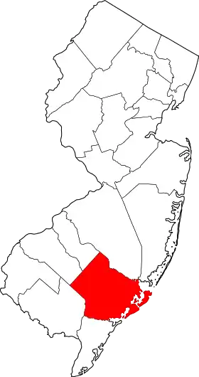 Localisation du comté dans l'État. | |
Le comté est créé le à partir du comté de Gloucester[1].
Comtés adjacents
- Comté de Burlington - nord
- Comté d'Ocean - nord-est
- Comté de Cape May - sud
- Comté de Cumberland - sud-ouest
- Comté de Camden - nord-ouest
- Comté de Gloucester - nord-ouest
Municipalités
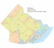
Carte des municipalités du comté.
- Absecon (11)
- Atlantic City (10)
- Brigantine (12)
- Buena (17)
- Buena Vista Township (18)
- Corbin City (2)
- Egg Harbor City (14)
- Egg Harbor Township (21)
- Estell Manor (1)
- Folsom (16)
- Galloway Township (22)
- Hamilton Township (20)
- Hammonton (15)
- Linwood (5)
- Longport (4)
- Margate City (6)
- Mullica Township (23)
- Northfield (7)
- Pleasantville (9)
- Port Republic (13)
- Somers Point (3)
- Ventnor City (8)
- Weymouth Township (19)
Politique
Le comté vote de manière générale en faveur du Parti démocrate, notamment grâce aux voix d'Atlantic City. Les villes côtières — attirant de nombreux retraités — et les petites villes de l'intérieur des terres tendent davantage vers les républicains[2].
Démographie
| Historique des recensements | |||
| Ann. | Pop. | %± | |
|---|---|---|---|
| 1840 | 8 726 | — | |
| 1850 | 8 961 | ▲ +2,69 % | |
| 1860 | 11 786 | ▲ +31,53 % | |
| 1870 | 14 093 | ▲ +19,57 % | |
| 1880 | 18 704 | ▲ +32,72 % | |
| 1890 | 28 836 | ▲ +54,17 % | |
| 1900 | 46 402 | ▲ +60,92 % | |
| 1910 | 71 894 | ▲ +54,94 % | |
| 1920 | 83 914 | ▲ +16,72 % | |
| 1930 | 124 823 | ▲ +48,75 % | |
| 1940 | 124 066 | ▼ −0,61 % | |
| 1950 | 132 399 | ▲ +6,72 % | |
| 1960 | 160 880 | ▲ +21,51 % | |
| 1970 | 175 043 | ▲ +8,8 % | |
| 1980 | 194 119 | ▲ +10,9 % | |
| 1990 | 224 327 | ▲ +15,56 % | |
| 2000 | 252 552 | ▲ +12,58 % | |
| 2010 | 274 549 | ▲ +8,71 % | |
| 2020 | 274 534 | ▼ −0,01 % | |
| Groupe | Comté de Atlantic | ||
|---|---|---|---|
| Blancs | 65,4 | 68,6 | 72,4 |
| Afro-Américains | 16,1 | 13,7 | 12,6 |
| Autres | 7,4 | 6,4 | 6,4 |
| Métis | 3,2 | 2,3 | 2,9 |
| Asiatiques | 7,5 | 8,6 | 4,8 |
| Amérindiens | 0,4 | 0,3 | 0,9 |
| Total | 100 | 100 | 100 |
| Hispaniques et Latino-Américains | 16,8 | 17,7 | 16,7 |
Notes et références
- (en) John P. Snyder, The Story of New Jersey's Civil Boundaries: 1606-1968, Trenton, Bureau of Geology and Topography, (lire en ligne), p. 67.
- (en) Micah Cohen, « In Blue New Jersey, Red Spots May Be Sign of the Past », Presidential Geography, sur fivethirtyeight.com, (consulté le ).
- (en) « Atlantic county, NJ Population - Census 2010 and 2000 », sur censusviewer.com
- (en) « Population of New Jersey - Census 2010 and 2000 », sur censusviewer.com
Voir aussi
Lien externe
- (en) Site officiel
- Ressource relative à la géographie :
Cet article est issu de wikipedia. Text licence: CC BY-SA 4.0, Des conditions supplémentaires peuvent s’appliquer aux fichiers multimédias.