Camp Académie
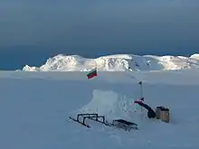
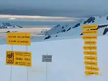
Le Camp Académie (en bulgare Лагер Академия, translittération scientifique internationale Lager Akademija) (62° 38′ 41″ S, 60° 10′ 18″ O) est une localité géographique dans l'Île Livingston, en Antarctique, nommée en l'honneur de l'Académie bulgare des Sciences et de sa contribution à l'exploration antarctique.


Historique
Le site se trouve dans un endroit stratégique, dans la partie haute du glacier Huron, près du pic Zograf, au centre de la montagne de Tangra, à une altitude de 541 m. Le Camp Académie est relié à la base bulgare Saint-Clément-d’Ohrid par une route terrestre de 11 km, et à la base antarctique espagnole Juan Carlos I par une route de 12,5 km.
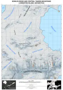
Le Camp Académie offre un accès commode à la montagne de Tangra au sud, aux zones des arêtes de Bowles, aux hauteurs de Vidin, au glacier du Kaljakra et au champ de neige de Săedinenie au nord, au glacier Huron à l’est, et aux glaciers Perunika et Huntress à l’ouest.
Le lieu a été occupé pour la première fois par l’expédition topographique bulgare Tangra 2004/05, du au . L’information géographique a été relevée pour des zones éloignées de l'Île Livingston et de l'Île Greenwich : 150 objets géographiques ont été cartographiés pour la première fois, et une carte topographique nouvelle des deux îles a été publiée en 2005. Le Camp Académie fait office depuis 2004 de bureau de poste estival sous l'appellation Tangra 1091, et constitue ainsi l'implantation la plus méridionale des Postes Bulgares.
Articles connexes
Cartes
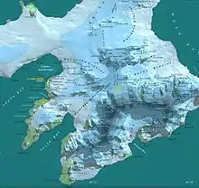
- (en) L.L. Ivanov et al, Antarctica: Livingston Island, South Shetland Islands (from English Strait to Morton Strait, with illustrations and ice-cover distribution), 1:100000 scale topographic map, Antarctic Place-names Commission of Bulgaria, Sofia, 2005
- (en) L.L. Ivanov. Antarctica: Livingston Island and Greenwich, Robert, Snow and Smith Islands. Scale 1:120000 topographic map. Troyan: Manfred Wörner Foundation, 2009. (ISBN 978-954-92032-6-4)
- (en) A. Kamburov and L. Ivanov. Bowles Ridge and Central Tangra Mountains: Livingston Island, Antarctica. Scale 1:25000 map. Sofia: Manfred Wörner Foundation, 2023. (ISBN 978-619-90008-6-1)
Liens externes
Références
- (en) L.L. Ivanov, Livingston Island : Tangra Mountains, Komini Peak, west slope new rock route ; Lyaskovets Peak, first ascent ; Zograf Peak, first ascent ; Vidin Heights, Melnik Peak, Melnik Ridge, first ascent, American Alpine Journal, 2005, 312-315.
- (en) Livingston Island, Climb Magazine, no 14, Kettering, avril 2006, p. 89-91
- (en) Gildea, D. Mountaineering in Antarctica: complete guide: Travel guide. Primento and Editions Nevicata, 2015. (ISBN 978-2-51103-136-0)
- (en) Ivanov, L. General Geography and History of Livingston Island. In: Bulgarian Antarctic Research: A Synthesis. Eds. C. Pimpirev and N. Chipev. Sofia: St. Kliment Ohridski University Press, 2015. pp. 17-28. (ISBN 978-954-07-3939-7)
- (en) 14 November 2004: Tangra. Discovering Antarctica Timeline. Discovery Channel UK website, 2012.
- (en) L. Ivanov and N. Ivanova. The World of Antarctica. Generis Publishing, 2022. 241 pp. (ISBN 979-8-88676-403-1)