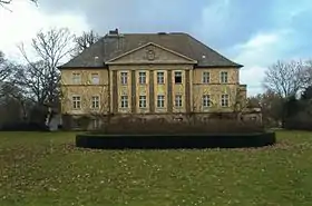
Aland (Altmark)
Aland est une commune allemande de l'arrondissement de Stendal, Land de Saxe-Anhalt.
| Aland | |||
| |||
| Administration | |||
|---|---|---|---|
| Pays | |||
| Land | |||
| Arrondissement (Landkreis) |
Stendal | ||
| Bourgmestre (Bürgermeister) |
Hans-Joachim Hildebrandt | ||
| Code postal | 39615 | ||
| Code communal (Gemeindeschlüssel) |
15 0 90 003 | ||
| Indicatif téléphonique | 039386, 039395, 039397 | ||
| Immatriculation | SDL, HV, OBG | ||
| Démographie | |||
| Population | 1 324 hab. () | ||
| Densité | 14 hab./km2 | ||
| Géographie | |||
| Coordonnées | 52° 57′ 33″ nord, 11° 38′ 12″ est | ||
| Altitude | 18 m |
||
| Superficie | 9 235 ha = 92,35 km2 | ||
| Localisation | |||
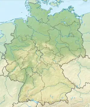
| Géolocalisation sur la carte : Allemagne
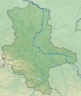
Géolocalisation sur la carte : Saxe-Anhalt
| |||
| Liens | |||
| Site web | www.vgem-seehausen.de/seite/166032/aland.html | ||
Géographie
Aland se situe tout au nord de la Saxe-Anhalt, au bord de l'Elbe qui forme la frontière avec le Brandebourg.
La commune comprend sept quartiers principaux :
|
|
|

Aland se trouve sur la Bundesstraße 189 et la ligne de Magdebourg à Wittenberge.
Histoire
La commune naît en de la fusion d'Aulosen, Krüden, Pollitz et Wanzer. Elle prend son nom de l'Aland, affluent de l'Elbe. En , Wahrenberg rejoint Aland.
Notes et références
Cet article est issu de wikipedia. Text licence: CC BY-SA 4.0, Des conditions supplémentaires peuvent s’appliquer aux fichiers multimédias.