West Lindsey
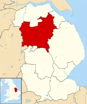
West Lindsey est un district non métropolitain du Lincolnshire, en Angleterre. Il est situé dans le nord du comté. Comme son nom l'indique, il correspond à la moitié ouest de l'ancienne subdivision de Lindsey. Son chef-lieu est Gainsborough.
| West Lindsey | |

| |
| Administration | |
|---|---|
| Pays | |
| Statut | District non métropolitain |
| Région | Midlands de l'Est |
| Comté | Lincolnshire |
| Chef-lieu | Gainsborough |
| Code ONS | 32UH |
| Démographie | |
| Population | 89 400 hab. (est. 2011) |
| Densité | 77 hab./km2 |
| Rang | 263e / 326 |
| Géographie | |
| Coordonnées | 53° 21′ nord, 0° 36′ ouest |
| Superficie | 115 600 ha = 1 156 km2 |
| Rang | 22e / 326 |
Composition
Le district est composé des villes et paroisses civiles suivantes :
- Aisthorpe
- Apley
- Bardney
- Barlings
- Bigby
- Bishop Norton
- Blyborough
- Blyton
- Brampton
- Brattleby
- Broadholme
- Brocklesby
- Brookenby
- Broxholme
- Bullington
- Burton
- Buslingthorpe
- Cabourne
- Caenby
- Caistor
- Cammeringham
- Cherry Willingham
- Claxby
- Cold Hanworth
- Corringham
- Dunholme
- East Ferry
- East Stockwith
- Faldingworth
- Fenton
- Fillingham
- Fiskerton
- Friesthorpe
- Fulnetby
- Gainsborough
- Gate Burton
- Glentham
- Glentworth
- Goltho
- Grange de Lings
- Grasby
- Grayingham
- Great Limber
- Greetwell
- Hackthorn
- Hardwick
- Harpswell
- Heapham
- Hemswell Cliff
- Hemswell
- Holton cum Beckering
- Holton le Moor
- Ingham
- Keelby
- Kettlethorpe
- Kexby
- Kirmond le Mire
- Knaith
- Laughton
- Lea
- Legsby
- Linwood
- Lissington
- Market Rasen
- Marton
- Middle Rasen
- Morton
- Nettleham
- Nettleton
- Newball
- Newton on Trent
- Normanby by Spital
- Normanby le Wold
- North Carlton
- North Kelsey
- Northorpe
- North Willingham
- Osgodby
- Owersby
- Owmby
- Pilham
- Rand
- Reepham
- Riby
- Riseholme
- Rothwell
- Saxby
- Saxilby with Ingleby
- Scampton
- Scothern
- Scotter
- Scotton
- Searby cum Owmby
- Sixhills
- Snarford
- Snelland
- Snitterby
- Somerby
- South Carlton
- South Kelsey
- Spridlington
- Springthorpe
- Stainfield
- Stainton by Langworth
- Stainton le Vale
- Stow
- Sturton by Stow
- Sudbrooke
- Swallow
- Swinhope
- Tealby
- Thonock
- Thoresway
- Thorganby
- Thorpe in the Fallows
- Toft Newton
- Torksey
- Upton
- Waddingham
- Walesby
- Walkerith
- Welton
- West Firsby
- West Rasen
- Wickenby
- Wildsworth
- Willingham
- Willoughton
Histoire

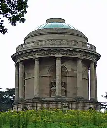
Charles Anderson-Pelham, 1er baron de Yarborough fit construire par James Wyatt, un mausolée dans Brocklesby Park, près de Crowle, en mémoire de son épouse Sophia (née Aufrere) décédée en 1787. Le mausolée fut achevé en 1792. William Turner, connu pour avoir fait des aquarelles pour Lord Yarborough, visita Brocklesby lors de sa tournée dans le Nord en 1797, et a dessiné l'extérieur du mausolée dans le carnet de Croquis du Mausolée de Brocklesby[1]. Le Diagramme 76 utilisé par Turner pour ses cours de perspective, représente l'intérieur du mausolée. Il est lui aussi conservé à la Tate Britain de Londres[2].