Tongaporutu
Tongaporutu est une localité du Nord de la région de Taranaki, située dans l’Île du Nord de la Nouvelle-Zélande.
| Tongaporutu | |||
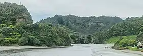
 La rivière Tongaporutu au niveau de la localité du même nom | |||
| Administration | |||
|---|---|---|---|
| Pays | |||
| Île | Île du Nord | ||
| Région | Taranaki | ||
| Autorité territoriale | district de New Plymouth | ||
| Géographie | |||
| Coordonnées | 38° 29′ 28″ sud, 174° 21′ 19″ est | ||
| Localisation | |||
| Géolocalisation sur la carte : Nouvelle-Zélande
Géolocalisation sur la carte : Nouvelle-Zélande
| |||
Situation
Elle est située sur le trajet de la route State Highway 3/S H 3 (en), à l’embouchure de la rivière Tongaporutu, à 15 kilomètres au sud de la ville de Mokau.
Géologie
Tongaporutu est bien connue en Nouvelle-Zélande pour sa formation rocheuse dite des « Three Sisters» et ses pétrographes Maori sculptés sur les murs de sa grotte rocheuse. Toutefois, aussi bien les sculptures Maori gravées dans la roche, que la formation des « Three Sisters » sont très érodées par l’air de la mer de Tasman toute proche .
Voir aussi
Notes et références
- (en) Cet article est partiellement ou en totalité issu de l’article de Wikipédia en anglais intitulé « Tongaporutu » (voir la liste des auteurs).
Autres lectures
Ouvrages généraux historiques
- (en) History of the Te Horo Tunnel and the Main Road North from New Plymouth to Mokau, New Plymouth, [N.Z.], Te Horo Restoration Society,
- (en) Tongaporutu, Ahititi, Okau: centennial booklet 1897-1997, New Plymouth, [N.Z.], n.p.,
- (en) Brian E. Gray, The Tongaporutu River Valley: a history of the combined districts of Tongaporutu, Ahititi, Okau, Kotare, Rerekapa, Inglewood, [N.Z.], Tongaporutu Historical Committee,
Histoire des activités
- (en) Margaret de Jardine, The little ports of Taranaki: being Awakino, Mokau, Tongaporutu, Urenui, Waitara, Opunake, Patea, together with some historical background to each, New Plymouth, [N.Z.], M. de Jardine, (ISBN 0-473-01455-6)
- (en) « Puke Ariki » dans:lieu=New Plymouth contient le recueil des lettres de l’agent de la compagnie de bateau, stationné au niveau de Waitara, Lewis Clare (mort en 1960).
Ce livre enregistre les transports maritimes costiers à partir et en direction du petit port de North Taranaki (incluant ceux mentionnés dans le livre de de Jardine ) entre les années 1910 et 1920. voir (en) « Clare, Lewis (ARC2002-255) » (consulté le )
Anglicanes
- (en) Parochial District of Saint Peter-by-the-Sea, Mokau: "come unto me"., Mokau, [N.Z.], Parochial District of Saint Peter-by-the-Sea,
Géologie
- 1927">(en) L.I. Grange et <Please add first missing authors to populate metadata.>, The geology of the Tongaporutu-Ohura Subdivision, Taranaki Division [Bulletin (New Zealand Geological Survey Branch); new ser. no. 31], Wellington, [N.Z.], Geological Survey Branch, New Zealand Department of Scientific and Industrial Research,
- (en) G.E. Harris, Geological map of Aria survey district, Wellington, [N.Z.], The Survey, Scale: 1: 63 360 (i.e. 1 in. to the mile)
- (en) G.E. Harris, Geological map of Mimi survey district, Wellington, [N.Z.], The Survey année= 1926 Scale: 1: 63 360 (i.e. 1 in. to the mile)
- (en) G.E. Harris, Geological map of Ohura survey district, Wellington, [N.Z.], The Survey, Scale: 1: 63 360 (i.e. 1 in. to the mile)
- ">">G.E. Harris, Geological map of Pouatu survey district, Wellington, [N.Z.], The Survey, 1926 > Scale: 1: 63 360 (i.e. 1 in. to the mile)
- G.E. Harris, Geological map of Waro survey district, Wellington, [N.Z.], The Survey, Scale: 1: 63 360 (i.e. 1 in. to the mile)
- Carey R. Mills, Gravity expression of the Patea-Tongaporutu High-lieu=eastern Taranaki, North Island, New Zealand (M.Sc., Victoria University of Wellington),
Maori
- F.L. Phillips, Landmarks of Tainui = Nga tohu a Tainui: a geographical record of Tainui traditional history, Otorohanga, [N.Z.], Tohu Publishers, 1989–1995 (ISBN 0-908596-26-X)
- F.L. Phillips, Landmarks of Tainui = Nga tohu a Tainui: a geographical record of Tainui traditional history, volume two, Otorohanga, [N.Z.], Tohu Publishers, (ISBN 0-908596-32-4)
Cartes
- A.L. Haylock, Tongaporutu improved farms settlement: Mimi survey district, Wellington, [N.Z.], New Zealand Department of Lands & Survey, Scale: 1: 39 600 (i.e. 1/1.6 in. to the mile)
- H.M. Skeet, Village of Tongaporutu, Mimi Survey District, Wellington, [N.Z.], New Zealand Department of Lands & Survey, Scale: 1: 3 168 (i.e. 1/20 in. to the mile)
- New Zealand Department of Lands & Survey, Tongaporutu, Wellington, [N.Z.], New Zealand Department of Lands & Survey, Scale: 1: 50 000 (i.e. 1/1.27 in. to the mile) NZMS 260 ; v Q18
Personnalités notables
- Information Généalogique, une famille de la Bible, et des ‘sketches’ de la rivière Mohakatino et Tongaporutu sont contenus dans la famille Messenger détenu dans(en) « Puke Ariki » lieu= New Plymouth. William Messenger, sa femme :Mary, et leurs enfants adultes s’installèrent initialement au niveau de Omata en arrivant en Nouvelle-Zélande en 1853. voir (en) « Messenger family »
- Pat Greenfield Taranaki Daily News profile

