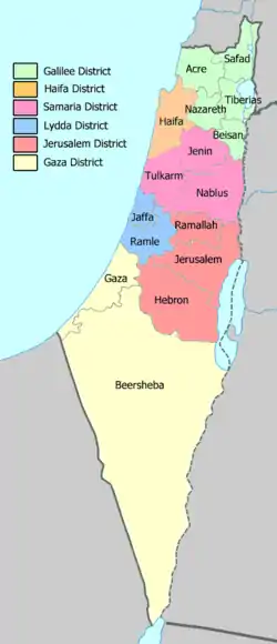
Sous-districts de la Palestine mandataire
Il y a 18 sous-districts de la Palestine mandataire.

Sous-districts et district en 1945.
Population de la Palestine par sous-district en 1945
| Population de la Palestine par sous-district en 1945 | |||||||
| Subdistrict | Musulmans | Pourcentage | Juifs | Pourcentage | Chrétiens | Pourcentage | Total |
| Acre | 51 130 | 69 % | 3 030 | 4 % | 11 800 | 16 % | 73 600 |
| Beer-sheva | 6 270 | 90 % | 510 | 7 % | 210 | 3 % | 7 000 |
| Beït Shéan | 16 660 | 67 % | 7 590 | 30 % | 680 | 3 % | 24 950 |
| Gaza | 145 700 | 97 % | 3 540 | 2 % | 1 300 | 1 % | 150 540 |
| Haïfa | 95 970 | 38 % | 119 020 | 47 % | 33 710 | 13 % | 253 450 |
| Hébron | 92 640 | 99 % | 300 | <1 % | 170 | <1 % | 93 120 |
| Jaffa | 95 980 | 24 % | 295 160 | 72 % | 17 790 | 4 % | 409 290 |
| Jénine | 60 000 | 98 % | Négligeable | <1 % | 1 210 | 2 % | 61 210 |
| Jérusalem | 104 460 | 42 % | 102 520 | 40 % | 46 130 | 18 % | 253 270 |
| Nablus | 92 810 | 98 % | Négligeable | <1 % | 1 560 | 2 % | 94 600 |
| Nazareth | 30 160 | 60 % | 7 980 | 16 % | 11 770 | 24 % | 49 910 |
| Ramallah | 40 520 | 83 % | Négligeable | <1 % | 8 410 | 17 % | 48 930 |
| Ramle | 95 590 | 71 % | 31 590 | 24 % | 5 840 | 4 % | 134 030 |
| Safed | 47 310 | 83 % | 7 170 | 13 % | 1 630 | 3 % | 56 970 |
| Tiberias | 23 940 | 58 % | 13 640 | 33 % | 2 470 | 6 % | 41 470 |
| Tulkarem | 76 460 | 82 % | 16 180 | 17 % | 380 | 1 % | 93 220 |
| Total | 1 076 780 | 58 % | 608 230 | 33 % | 145 060 | 9 % | 1 845 560 |
| Données provenant de Survey of Palestine[1] | |||||||
Propriétaires des terres par sous-district
Le tableau ci-dessous montre l’appartenance des terres de Palestine par sous-district.
| Appartenance des terres de Palestine par sous-district en 1945 | ||||||
| Subdistrict | Appartenant à des Arabes | Appartenant à des Juifs | Publiques et autres | |||
| Acre | 87 % | 3 % | 10 % | |||
| Beer-sheva | 15 % | <1 % | 85 % | |||
| Beït Shéan | 44 % | 34 % | 22 % | |||
| Gaza | 75 % | 4 % | 21 % | |||
| Haïfa | 42 % | 35 % | 23 % | |||
| Hébron | 96 % | <1 % | 4 % | |||
| Jaffa | 47 % | 39 % | 14 % | |||
| Jenine | 84 % | <1 % | 16 % | |||
| Jérusalem | 84 % | 2 % | 14 % | |||
| Nablus | 87 % | <1 % | 13 % | |||
| Nazareth | 52 % | 28 % | 20 % | |||
| Ramallah | 99 % | <1 % | 1 % | |||
| Ramle | 77 % | 14 % | 9 % | |||
| Safed | 68 % | 18 % | 14 % | |||
| Tiberias | 51 % | 38 % | 11 % | |||
| Tulkarem | 78 % | 17 % | 5 % | |||
| Données provenant de Land Ownership of Palestine[2] | ||||||
Référence
- (en) prepared in December 1945 and January 1946 for the information of the Anglo-American Committee of Inquiry, A Survey of Palestine : Prepared in December, 1945 and January, 1946 for the Information of the Anglo-American Committee of Inquiry, vol. 1, Washington, Institute for Palestine Studies, , 544 p., relié (ISBN 978-0-88728-211-9, LCCN 90005245), p. 12–13.
- Land Ownership of Palestine — Carte préparée par le gouvernement de Palestine d’après les instructions du UN Ad Hoc Committee on the Palestine Question.
Cet article est issu de wikipedia. Text licence: CC BY-SA 4.0, Des conditions supplémentaires peuvent s’appliquer aux fichiers multimédias.