San Nicolas (Batangas)
San Nicolas (en tagalog : Bayan ng San Nicolas) est une municipalité de la province de Batangas, au sud de l’île de Luçon, aux Philippines.

| Nom officiel |
(en) Municipality of San Nicolas |
|---|
| Pays | |
|---|---|
| Groupe d'îles |
Luzon (en) |
| Région | |
| Province | |
| Superficie |
14,37 km2 |
| Altitude |
47 m |
| Coordonnées |
13° 55′ 42″ N, 120° 57′ 04″ E |

| Population |
23 908 hab. () |
|---|---|
| Densité |
1 663,7 hab./km2 () |
| Statut |
|---|
| Fondation |
|---|
| Code postal |
4207 |
|---|---|
| Indicatif téléphonique |
43 |

Lors du recensement de 2020, sa population s'élève à 23 908 habitants.
Géographie
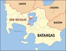
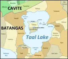
San Nicolas a la particularité d'avoir son territoire situé pour la moitié sur Volcano Island, île volcanique au centre du lac de cratère Taal, et pour l'autre moitié en bordure sud-ouest de ce lac.
Le fleuve Pansipit, exutoire du lac, qui se jette dans la baie de Balayan (en), sépare San Nicolas de la municipalité d'Agoncillo au nord. Deux autres municipalités, Taal et Santa Teresita, sont limitrophes de San Nicolas au sud-ouest et au sud. Sur Volcano Island, la municipalité de Talisay est située au nord de San Nicolas.

D'une superficie totale de 14,37 kilomètres carrés, elle est divisée administrativement en 18 barangays :
- Abelo
- Balete
- Baluk-baluk
- Bancoro
- Bangin
- Calangay
- Hipit
- Maabud North
- Maabud South
- Munlawin
- Pansipit
- Poblacion
- Santo Niño
- Sinturisan
- Tagudtod
- Talang
- Alas-as
- Pulang-Bato
Histoire
En 1955, les barrios de San Nicolas, Hipit, Bangin, Pansipit, Calangay, Sinturisan, Talang, Abelo, Balete, Bancoro, Saimsim, Maabud, Munlawin, Tambo, Calumala, Alas-as, Calawit et Pulang-Bato ont été séparés de la municipalité de Taal pour constituer une nouvelle municipalité distincte, appelée San Nicolas[1] ; en 1957, cinq barrios ont été transformés en barangays indépendants par séparation : Burol de Tambo[2], Tagudtod de Munlawin[3], Kalawit et Pulang-Bato d'Alas-as[4] - [5] et Baluk-Baluk de Hipit[6].
En 1961, les barrios de Calumala, Tambo, Saimsim et Bucal sont séparés de San Nicolas et annexés à la nouvelle municipalité de Santa Teresita[7].
| 1960 | 1970 | 1975 | 1980 | 1990 | 1995 | 2000 | 2007 | 2010 | 2015 | 2020 |
|---|---|---|---|---|---|---|---|---|---|---|
| 9575 | 8742 | 8877 | 10511 | 13174 | 14509 | 16278 | 19046 | 20599 | 22623 | 23908 |
Notes et références
- (en) « An Act Creating the Municipality of San Nicolas, Province of Batangas. Republic Act No. 1229 », sur https://thecorpusjuris.com.
- « Republic Act No. 1684. An Act Creating the Barrio of Burol in the Municipality of San Nicolas, Province of Batangas », sur https://lawphil.net.
- « Republic Act No. 1683. An Act Creating the Barrio of Tagodtod in the Municipality of San Nicolas, Province of Batangas », sur https://lawphil.net.
- « Republic Act No. 1687. An Act Creating the Barrio of Kalawit in the Municipality of San Nicolas, Province of Batangas », sur https://lawphil.net.
- « Republic Act No. 1685. An Act Creating the Barrio of Pulang-Bato in the Municipality of San Nicolas, Province of Batangas », sur https://lawphil.net.
- « Republic Act No. 1686. An Act Creating the Barrio of Baluk-Baluk in the Municipality of San Nicolas, Province of Batangas », sur https://lawphil.net.
- (en) « Executive Order No. 454 : Creating the municipality of Sta. Teresita in the Province of Batangas », Official Gazette of the Republic of the Philippines, vol. 58, no 3, , p. 363-364 (lire en ligne).
- (en) « Province of Batangas », sur Municipality Population Data.