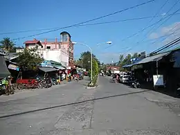
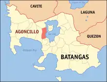
Agoncillo
Agoncillo est une municipalité de la province de Batangas. Elle fut nommée ainsi en honneur de Felipe Agoncillo en 1949[1].
Agoncillo

| Nom officiel |
(en) Municipality of Agoncillo |
|---|
| Pays | |
|---|---|
| Groupe d'îles |
Luzon (en) |
| Région | |
| Province | |
| Superficie |
49,96 km2 |
| Altitude |
110 m |
| Coordonnées |
13° 56′ 00″ N, 120° 55′ 43″ E |
| Population |
39 101 hab. () |
|---|---|
| Densité |
782,6 hab./km2 () |
| Statut |
|---|
| Fondation |
|---|
| Code postal |
4211 |
|---|---|
| Indicatif téléphonique |
43 |

Elle compte 21 barangays:
|
|
Références
- (en) Spencer C. Tucker (dir.), The Encyclopedia of the Spanish-American and Philippine-American Wars: A Political, Social, and Military History, vol. 1, ABC-CLIO, (ISBN 9781851099511, lire en ligne), p. 6-7
Cet article est issu de wikipedia. Text licence: CC BY-SA 4.0, Des conditions supplémentaires peuvent s’appliquer aux fichiers multimédias.