Indicatif régional 979
L'indicatif régional 979 est l'un des multiples indicatifs téléphoniques régionaux de l'État du Texas aux États-Unis.

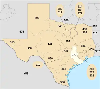
Carte de l'État du Texas avec les territoires de ses indicatifs régionaux. L'indicatif régional 979 est en blanc.
Cet indicatif dessert une région qui suit à peu près le fleuve Brazos, du sud de Waco jusqu'au golfe du Mexique.
La carte ci-contre indique en blanc le territoire couvert par l'indicatif 979.
L'indicatif régional 979 fait partie du plan de numérotation nord-américain.
Comtés desservis par l'indicatif
Villes desservies par l'indicatif
- Alleyton ;
- Altair ;
- Angleton ;
- Bay City ;
- Beasley ;
- Bellville ;
- Bleiblerville ;
- Boling ;
- Brazoria ;
- Brenham ;
- Bryan ;
- Burton ;
- Caldwell ;
- Calvert ;
- Carmine ;
- Cat Spring ;
- Chappell Hill ;
- Chriesman ;
- Clute ;
- College Station ;
- Columbus ;
- Damon ;
- Danbury ;
- Danciger ;
- Danevang ;
- Deanville ;
- Dime Box ;
- Eagle Lake ;
- East Bernard ;
- Egypt ;
- El Campo ;
- Ellinger ;
- Fayetteville ;
- Franklin ;
- Freeport ;
- Garwood ;
- Gause ;
- Giddings ;
- Glen Flora ;
- Guy ;
- Hearne ;
- Hempstead ;
- Hungerford ;
- Industry ;
- Kendleton ;
- Kenney ;
- Kurten ;
- La Grange ;
- Lake Jackson ;
- Lane City ;
- Ledbetter ;
- Lexington ;
- Lincoln ;
- Louise ;
- Lyons ;
- Markham ;
- Matagorda ;
- Nada ;
- Needville ;
- New Baden ;
- New Ulm ;
- Oakland ;
- Old Ocean ;
- Orchard ;
- Pledger ;
- Plum ;
- Prairie Hill ;
- Pine Island ;
- Rock Island ;
- Round Top ;
- San Felipe ;
- Schulenburg ;
- Sealy ;
- Sheridan ;
- Somerville ;
- Sweeny ;
- Van Vleck ;
- Wadsworth ;
- Wallis ;
- Warda ;
- Warrenton ;
- Weimar ;
- Wellborn ;
- West Columbia ;
- West Point ;
- Wharton ;
- Wheelock.
Voir aussi
Lien externe
Cet article est issu de wikipedia. Text licence: CC BY-SA 4.0, Des conditions supplémentaires peuvent s’appliquer aux fichiers multimédias.