Hirslanden (Zurich)
Hirslanden est un quartier faisant partie du 7e arrondissement de Zurich.
Hirslanden


| Pays | |
|---|---|
| Commune | |
| Kreis (city of Zürich) |
District 7 (en) |
| Canton | |
| Altitude |
469 m |
| Coordonnées |
47° 21′ 53″ N, 8° 33′ 59″ E |
| Population |
7 465 hab. () |
|---|
| Statut |
Ancienne commune de Suisse (d), statistical neighborhood of Zürich (d), commune de Suisse (jusqu'en ) |
|---|
| Code postal |
8032 |
|---|---|
| Immatriculation |
ZH |

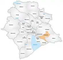
Géographie
Hirslanden est situé sur le côté ouest de l’Adlisberg.
Historique
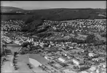
Vue aérienne (1953)
Hirslanden était une commune à part entière. Elle a été incorporée à Zurich en 1893.
Notes et références
Cet article est issu de wikipedia. Text licence: CC BY-SA 4.0, Des conditions supplémentaires peuvent s’appliquer aux fichiers multimédias.