Harrisonburg (Virginie)
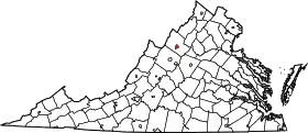
Harrisonburg est une ville de l'État de Virginie, à l'est des États-Unis. En 2010, sa population était de 48 914 habitants.
| Harrisonburg | ||||

| ||||
| Administration | ||||
|---|---|---|---|---|
| Pays | ||||
| État | ||||
| Comté | Ville indépendante | |||
| Maire | Rodney Eagle | |||
| Démographie | ||||
| Population | 40 468 hab. (2000) | |||
| Densité | 887 hab./km2 | |||
| Géographie | ||||
| Coordonnées | 38° 26′ 35″ nord, 78° 52′ 21″ ouest | |||
| Superficie | 4 560 ha = 45,6 km2 | |||
| · dont terre | 45,5 km2 (99,78 %) | |||
| · dont eau | 0,1 km2 (0,22 %) | |||
| Fuseau horaire | EST (UTC-5) | |||
| Divers | ||||
| Fondation | 1779 | |||
| Surnom | « The Friendly City » (« La cité amicale ») |
|||
| Localisation | ||||
 | ||||
| Géolocalisation sur la carte : États-Unis
Géolocalisation sur la carte : États-Unis
Géolocalisation sur la carte : Virginie
| ||||
| Liens | ||||
| Site web | http://www.harrisonburgva.gov | |||
Ville indépendante, elle fut fondée en 1779 et porte le nom de Thomas Harrison (1704–1785).
Démographie
| Historique des recensements | |||
| Ann. | Pop. | %± | |
|---|---|---|---|
| 1860 | 1 023 | — | |
| 1870 | 2 036 | ▲ +99,02 % | |
| 1880 | 2 831 | ▲ +39,05 % | |
| 1890 | 2 792 | ▼ −1,38 % | |
| 1900 | 3 521 | ▲ +26,11 % | |
| 1910 | 4 879 | ▲ +38,57 % | |
| 1920 | 5 875 | ▲ +20,41 % | |
| 1930 | 7 232 | ▲ +23,1 % | |
| 1940 | 8 768 | ▲ +21,24 % | |
| 1950 | 10 810 | ▲ +23,29 % | |
| 1960 | 11 916 | ▲ +10,23 % | |
| 1970 | 14 605 | ▲ +22,57 % | |
| 1980 | 19 671 | ▲ +34,69 % | |
| 1990 | 30 707 | ▲ +56,1 % | |
| 2000 | 40 468 | ▲ +31,79 % | |
| 2010 | 48 914 | ▲ +20,87 % | |
| Est. 2017 | 54 215 | ▲ +10,84 % | |
Liens externes
- Ressource relative à la géographie :
- (en) James Madison University
- (en) Cité de Harrisonburg
Cet article est issu de wikipedia. Text licence: CC BY-SA 4.0, Des conditions supplémentaires peuvent s’appliquer aux fichiers multimédias.
_relief_location_map.png.webp)
_location_map.svg.png.webp)
