Fljótsdalshreppur
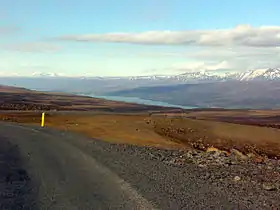
Fljótsdalshreppur est une municipalité du nord-est de l'Islande.
| Fljótsdalshreppur | |
 Héraldique |
|
| |
| Administration | |
|---|---|
| Pays | |
| Région | Austurland |
| Circonscription | Norðausturkjördæmi |
| Comté | Norður-Múlasýsla |
| Maire Mandat |
Gunnþórunn Ingólfsdóttir (2010-2014) |
| Code postal | 701 |
| Code municipal | 7505 |
| Démographie | |
| Population | 103 hab. (2022) |
| Densité | 0,07 hab./km2 |
| Géographie | |
| Coordonnées | 64° 50′ nord, 15° 30′ ouest |
| Superficie | 151 600 ha = 1 516 km2 |
| Localisation | |
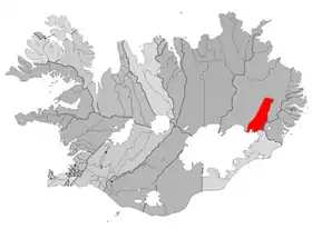 Situation de Fljótsdalshreppur | |
| Liens | |
| Site web | www.fljotsdalur.is |
Démographie
| Date | Population |
|---|---|
| 1998 | 100 |
| 1999 | 96 |
| 2000 | 90 |
| 2001 | 86 |
| 2002 | 82 |
| 2003 | 84 |
| 2004 | 100 |
| 2005 | 260 |
| 2006 | 376 |
| 2007 | 526 |
| 2008 | 394 |
| 2009 | 135 |
| 2010 | 89 |
| 2011 | 80 |
| 2022 | 103 |
Notes et références
Cet article est issu de wikipedia. Text licence: CC BY-SA 4.0, Des conditions supplémentaires peuvent s’appliquer aux fichiers multimédias.