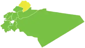
District d'an-Nabk
Le District d'an-Nabk (en arabe : منطقة النبك, manṭiqat an-Nabk) est l'un des dix districts du Gouvernorat de Rif Dimachq, situé dans le sud de la Syrie ; son centre administratif est la ville d'an-Nabk. D'après le Bureau central des statistiques syrien, sa population était de 80 001 habitants en 2004.
| District d'an-Nabk منطقة النبك (ar) | |
 Localisation du district d'an-Nabk, dans le gouvernorat de Rif Dimachq. | |
| Administration | |
|---|---|
| Pays | |
| Gouvernorat | Rif Dimachq |
| Démographie | |
| Population | 80 001 hab. (2004) |
| Densité | 71 hab./km2 |
| Géographie | |
| Coordonnées | 34° 01′ nord, 36° 43′ est |
| Superficie | 112 287 ha = 1 122,87 km2 |
Sous-districts
Le district d'an-Nabk est divisé en trois sous-districts (ou nahiés), (population en 2004[1]) :
Localités
| Nom | Nom en arabe | Population | Sous-district |
|---|---|---|---|
| an-Nabk | النبك | 32 548 | an-Nabk |
| Qara | قارة | 12 508 | Qara |
| Deir Atiyah | دير عطية | 10 984 | Deir Atiyah |
| Flitah | فليطة | 6 475 | an-Nabk |
| al-Sahel | السحل | 5 677 | an-Nabk |
| al-Jarajir | الجراجير | 4 022 | Deir Atiyah |
| al-Qastal | القسطل | 3 486 | an-Nabk |
| Qaldoun al-Marah | قلدون المراح | 2 561 | an-Nabk |
| al-Humayra | الحميرة | 1 740 | Qara |
Références
- Rapport de recensement du Bureau central des statistiques syrien (2004). (ar) Lire en ligne
Cet article est issu de wikipedia. Text licence: CC BY-SA 4.0, Des conditions supplémentaires peuvent s’appliquer aux fichiers multimédias.