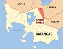
Santo Tomas (Batangas)
Santo Tomas est une municipalité de la province de Batangas.
Santo Tomas

| Nom officiel |
(en) City of Santo Tomas (depuis ) |
|---|
| Pays | |
|---|---|
| Groupe d'îles |
Luzon (en) |
| Région | |
| Province | |
| Superficie |
95,41 km2 |
| Altitude |
239 m |
| Coordonnées |
14° 05′ N, 121° 11′ E |
| Population |
218 500 hab. () |
|---|---|
| Densité |
2 290,1 hab./km2 () |
| Statut |
Component city (en) (depuis le ) |
|---|
| Origine du nom | |
|---|---|
| Fondation |
| Code postal |
4234 |
|---|---|
| Indicatif téléphonique |
43 |
| Site web |

Cet article est issu de wikipedia. Text licence: CC BY-SA 4.0, Des conditions supplémentaires peuvent s’appliquer aux fichiers multimédias.