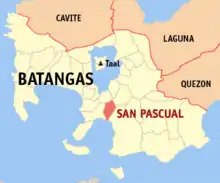
San Pascual (Batangas)
San Pascual est une municipalité des Philippines située dans la province de Batangas, sur l'île de Luçon.
San Pascual
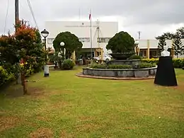
L'hôtel de ville de San Pascual.
| Nom officiel |
(en) Municipality of San Pascual |
|---|
| Pays | |
|---|---|
| Groupe d'îles |
Luzon (en) |
| Région | |
| Province | |
| Superficie |
50,7 km2 |
| Altitude |
46 m |
| Coordonnées |
13° 48′ N, 121° 02′ E |
| Population |
69 009 hab. () |
|---|---|
| Nombre de ménages |
17 717 () |
| Densité |
1 361,1 hab./km2 () |
| Électorat |
41 762 |
| Statut |
|---|
| Origine du nom | |
|---|---|
| Fondation |
| Code postal |
4204 |
|---|---|
| Indicatif téléphonique |
43 |

Barangays
La municipalité est divisée en 29 barangays (districts) :
- Alalum
- Antipolo
- Balimbing
- Banaba
- Bayanan
- Danglayan
- Del Pilar
- Gelerang Kawayan
- Ilat North
- Ilat South
- Kaingin
- Laurel
- Malaking Pook
- Mataas Na Lupa
- Natunuan North
- Natunuan South
- Padre Castillo
- Palsahingin
- Pila
- Poblacion
- Pook Ni Banal
- Pook Ni Kapitan
- Resplandor
- Sambat
- San Antonio
- San Mariano
- San Mateo
- Santa Elena
- Sto. Nino
Notes et références
Cet article est issu de wikipedia. Text licence: CC BY-SA 4.0, Des conditions supplémentaires peuvent s’appliquer aux fichiers multimédias.