Liste des lieux patrimoniaux du comté de Digby
Cet article recense les lieux patrimoniaux du comté de Digby en Nouvelle-Écosse inscrit au répertoire des lieux patrimoniaux du Canada, qu'ils soient de niveau provincial, fédéral ou municipal.
Liste
| [1] | Lieu patrimonial | Illustration | Municipalité | Adresse | Coordonnées | No | Constr. | Prot.[2] | Rec. | Notes |
|---|---|---|---|---|---|---|---|---|---|---|
| M | Cimetière de la Pointe-à-Major | 
|
Anse-des-Belliveau | 245 Doucette Point Road | 44.3845 -66.0798 |
16023 | 1774 | Municipally Registered Property | 1993 | |
| M | Bayview United Church |
|
Bay View | 1074 Lighthouse Road | 44.6779 -65.7736 |
1316 | 1880 | Municipally Registered Property | 1990 | |
| F | Phare de Point Prim (en) |  |
Bay View | 44.690833 -65.786389 |
20770 | 1964 | Phare patrimonial | 2015 | ||
| F | Phare de Cap Sainte-Marie | .jpg.webp) |
Cape St. Marys (en) | 44.085892 -66.21104 |
20893 | 1969 | Phare patrimonial | 2015 | ||
| M | Centreville United Church |
|
Centreville | 34 Trout Cove Road | 44.5462 -66.0131 |
1319 | 1856 | Municipally Registered Property | 1993 | |
| M | Ward House |
|
Centreville | 215 Trout Cove Road | 44.5466 -66.0281 |
1375 | 1800 | Municipally Registered Property | 2001 | |
| P | St. John the Baptist Church |
|
Corberrie | No. 340 Highway | 44.2354 -65.9292 |
6238 | 1841 | Provincially Registered Property | 1991 | |
| M | Culloden Baptist Church |
|
Culloden (en) | 1643 Culloden Road | 44.6553 -65.8338 |
1338 | 1877 | Municipally Registered Property | 1990 | |
| F | Église anglicane Trinity | _05.jpg.webp) |
Digby | 87 Queen Street | 44.6192 -65.7567 |
10584 | 1878 | National Historic Site of Canada | 1990 | |
| P | Trinity Anglican Church | |
Digby | Queen Street | 44.6204 -65.7577 |
7266 | 1878 | Provincially Registered Property | 1994 | |
| P | Gilbert's Cove Lighthouse |  |
Gilbert's Cove | 244 Lighthouse Road | 44.4943 -65.9523 |
1261 | 1904 | Provincially Registered Property | 1991 | |
| M | Haight Residence |
|
Hillgrove | 1721 Ridge Road | 44.5264 -65.8022 |
1374 | 1850 | Municipally Registered Property | 1999 | |
| M | Captain Cheney's Homestead |
|
Little River | 86 Shore Road | 44.4441 -66.1398 |
1314 | 1910 | Municipally Registered Property | 1999 | |
| M | Little River United Baptist Church | 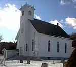 |
Little River | Highway 217 | 44.4428 -66.1491 |
1339 | 1880 | Municipally Registered Property | 1994 | |
| P | Gardenia Lodge-Savary House |
|
Plympton | No. 101 Highway | 44.5115 -65.9064 |
7992 | 1820 | Provincially Registered Property | 1990 | |
| M | Westway Inn |
|
Plympton | 5 French Road | 44.5044 -65.9161 |
1385 | 1835 | Municipally Registered Property | 1993 | |
| P | Église Sainte-Marie | 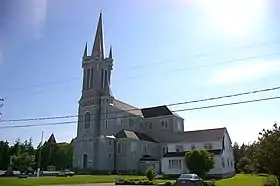 |
Pointe-de-l'Église | 1713 Higway No. 1 | 44.334 -66.1162 |
5390 | 1905 | Provincially Registered Property | 2001 | |
| P | Isaac LeBlanc House |
|
Pointe-de-l'Église | 33 Isaac LeBlanc Chemain | 44.3254 -66.1195 |
5388 | 1874 | Provincially Registered Property | 1997 | |
| P | All Saints Anglican Church and Cemetery |
|
Rossway | 10219 Route 217; Rossway | 44.5847 -65.9029 |
6236 | 1845 | Provincially Registered Property | 1991 | |
| M | Church of the Nativity |
|
Sandy Cove | 321 Sandy Cove Road | 44.4904 -66.0923 |
1318 | 1850 | Municipally Registered Property | 1993 | |
| M | Dickson Residence (Captain John Squires Eldridge House) |
|
Sandy Cove | 46 Bayshore Road | 44.4921 -66.0895 |
1372 | 1850 | Municipally Registered Property | 1999 | |
| M | Sandy Cove United Baptist Church |
|
Sandy Cove | 350 Sandy Cove Road | 44.4904 -66.09 |
1381 | 1850 | Municipally Registered Property | 1994 | |
| M | Zion United Church |
|
Sandy Cove | 325 Sandy Cove Road | 44.4907 -66.0921 |
1382 | 1856 | Municipally Registered Property | 1993 | |
| P | Smith's Cove Baptist Meeting House and Temperance Hall |
|
Smiths Cove | Highway No. 1 | 44.6112 -65.7066 |
3077 | 1837 | Provincially Registered Property | 1994 | |
| M | Smith's Cove United Church |
|
Smith's Cove | 660 Highway No.1 | 44.6124 -65.7027 |
1384 | 1885 | Municipally Registered Property | 1993 | |
| M | Former Southville Church of Christ |
|
Southville | 807 Langford Road | 44.3524 -65.8997 |
1379 | 1889 | Municipally Registered Property | 1999 | |
| M | Oddfellows Hall |
|
Westport | 7 Second Street | 44.2617 -66.3531 |
1343 | 1909 | Municipally Registered Property | 1994 | |
| P | Westport United Baptist Church |
|
Westport | 50 Wellington Street | 44.2612 -66.3542 |
4098 | 1850 | Provincially Registered Property | 1991 | |
| M | Fitzgerald House |
|
Weymouth | 74 Fort Point Road | 44.4382 -65.9983 |
1340 | 1835 | Municipally Registered Property | 2001 | |
| M | Former Saint Thomas Anglican Church |
|
Weymouth | 4668 Main Street | 44.4135 -65.996 |
1373 | 1864 | Municipally Registered Property | 1999 | |
| M | Payson House | 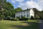 |
Weymouth | 4458 No. 1 Highway | 44.4047 -65.9988 |
6494 | Municipally Registered Property | 1999 | ||
| M | Stephen Payson Homestead | 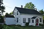 |
Weymouth | 4471 Highway Number one | 44.4053 -65.9985 |
1383 | 1845 | Municipally Registered Property | 2000 | |
| M | Weymouth Trading Post (Campbell's Store) | 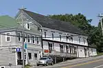 |
Weymouth | 4613 Highway Number One | 44.4112 -65.9962 |
1317 | 1863 | Municipally Registered Property | 1990 | |
| M | Bayside Farm |
|
Weymouth North | 580 Fort Point Road | 44.4531 -66.0024 |
1315 | 1860 | Municipally Registered Property | 1999 | |
| M | Saint Peter's Church |
|
Weymouth North | 5 Fort Point Branch | 44.4385 -65.9945 |
1377 | 1879 | Municipally Registered Property | 2000 |
Notes et références
- Niveau de la désignation: F: Fédéral, P: Provincial, M: Municipal
- (fr) Répertoire canadien des lieux patrimoniaux : Manuel de normes de documentation, Annexe A : Vocabulaires contrôlés, p.59-78
(en) Canadian Register of Historic Places: Documentation Standards Handbook, Appendix A: Controlled Vocabulary, p.57-75
Annexes
Articles connexes
Liens externes
- « Lieux patrimoniaux du Canada »
- « Annuaire des désignations patrimoniales fédérales », sur Parcs Canada
- (en) « Nova Scotia Register of Historic Places », sur The Nova Scotia Historic Places Initiative
Cet article est issu de wikipedia. Text licence: CC BY-SA 4.0, Des conditions supplémentaires peuvent s’appliquer aux fichiers multimédias.