Liste des lieux patrimoniaux du comté d'Inverness
Cet article recense les lieux patrimoniaux du comté d'Inverness en Nouvelle-Écosse inscrit au répertoire des lieux patrimoniaux du Canada, qu'ils soient de niveau provincial, fédéral ou municipal.
Liste
| [1] | Lieu patrimonial | Illustration | Municipalité | Adresse | Coordonnées | No | Constr. | Prot.[2] | Rec. | Notes |
|---|---|---|---|---|---|---|---|---|---|---|
| P | Paroisse Saint-Pierre | 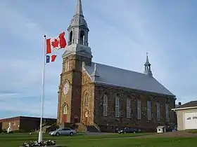 |
Chéticamp | Cabot Trail | 46.6246 -61.0157 |
7257 | 1893 | Provincially Registered Property | 2004 | |
| P | Paroisse Saint-Pierre | 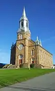 |
Chéticamp | 15 119 Cabot Trail Drive | 46.6255 -61.0161 |
8821 | 1893 | Provincially Registered Property | 2004 | |
| M | Saint Margaret of Scotland Catholic Church | 
|
Glendale | 3080 River Denys Road | 45.8671 -61.3048 |
11847 | 1841 | Municipally Registered Property | 1985 | |
| M | MacDonald House |
|
Glendyer | 356 Smithville Road | 46.0876 -61.3496 |
12059 | Municipally Registered Property | 1989 | ||
| M | Inverness Railway Station |  |
Inverness | 62 Lower Railway Street | 46.2311 -61.3091 |
11859 | 1900 | Municipally Registered Property | 1985 | |
| M | MacMillan-Cameron House |
|
Inverness | 15726 Highway 19; Inverness | 46.2266 -61.3087 |
8846 | Municipally Registered Property | 2002 | ||
| P | MacMillan-Cameron House |
|
Inverness | 15726 Central Avenue; Highway 19 | 46.2266 -61.3084 |
6529 | Provincially Registered Property | 2002 | ||
| M | Judique on the Floor Historical Society Building |
|
Judique | 5663 Highway 19 | 45.8863 -61.4899 |
15165 | Municipally Registered Property | 1996 | ||
| M | MacKeen-Smith House |
|
Mabou | 11247 Highway 19 | 46.066 -61.4041 |
12206 | Municipally Registered Property | 1985 | ||
| M | Saint Joseph's Roman Catholic Church |
|
Marble Mountain | 5621 Marble Mountain Road; Marble Mountain | 45.8204 -61.0414 |
8735 | 1905 | Municipally Registered Property | 1997 | |
| M | Big Intervale United Church |
|
Margaree Valley | 3207 East Big Intervale Road; Kingross | 46.4448 -60.9193 |
8851 | 1868 | Municipally Registered Property | 2002 | |
| F | Phare de Mabou |  |
McKeens Point | 46.087 -61.472 |
4221 | 1908 | ÉFP reconnu | 2004 | ||
| M | MacFarlane House |
|
Mull River | 1517 Mull River Road | 46.0048 -61.3594 |
15334 | 1871 | Municipally Registered Property | 1987 | |
| M | Orangedale Railway Station | 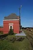 |
Orangedale | 1428 Orangedale Road | 45.9006 -61.0938 |
11800 | 1886 | Municipally Registered Property | 2008 | |
| P | Captain James Embree House |
|
Port Hawkesbury | 209 Granville Street | 45.6165 -61.3651 |
3555 | 1880 | Provincially Registered Property | 1995 | |
| M | Haus Treuburg |
|
Port Hood | 175 Main Street | 46.0149 -61.5307 |
15307 | Municipally Registered Property | 1997 | ||
| M | Peter Smyth House |
|
Port Hood | 342 Main Street; Port Hood | 46.0206 -61.5342 |
8734 | Municipally Registered Property | 1985 | ||
| P | Peter Smyth House |
|
Port Hood | 342 Main Street | 46.0206 -61.5342 |
3894 | 1855 | Provincially Registered Property | 1985 | |
| M | Jubilee United Church |
|
Port Hood Island | 179 Beach Road | 46.0164 -61.5636 |
15166 | 1904 | Municipally Registered Property | 2004 | |
| P | Campbell Heritage House |
|
Strathlorne | 340 Church Road | 46.1775 -61.2867 |
8229 | Provincially Registered Property | 1989 | ||
| P | Campbell-Rose House |
|
Strathlorne | 340 Church Road | 46.1816 -61.2771 |
11878 | Provincially Registered Property | 1989 | ||
| M | Robert and Lucinda MacDonald House |
|
Strathlorne | 14860 Highway 19 | 46.1898 -61.2872 |
15308 | Municipally Registered Property | 1996 | ||
| F | Phare |
|
Subdistrict B | Île Henry | 45.977 -61.5976 |
9624 | 1902 | Recognized Federal Heritage Building | 1991 | |
| M | Leonard House |
|
West Bay | 36 Manse Road | 45.7066 -61.1686 |
12015 | 1878 | Municipally Registered Property | 1991 |
Notes et références
- Niveau de la désignation: F: Fédéral, P: Provincial, M: Municipal
- (fr) Répertoire canadien des lieux patrimoniaux : Manuel de normes de documentation, Annexe A : Vocabulaires contrôlés, p.59-78
(en) Canadian Register of Historic Places: Documentation Standards Handbook, Appendix A: Controlled Vocabulary, p.57-75
Annexes
Articles connexes
Liens externes
Pour l'ensemble des points mentionnés sur cette page : voir sur OpenStreetMap (aide) ou télécharger au format KML (aide).
- « Lieux patrimoniaux du Canada »
- « Annuaire des désignations patrimoniales fédérales », sur Parcs Canada
- (en) « Nova Scotia Register of Historic Places », sur The Nova Scotia Historic Places Initiative
Cet article est issu de wikipedia. Text licence: CC BY-SA 4.0, Des conditions supplémentaires peuvent s’appliquer aux fichiers multimédias.