Liste des districts du Territoire de Pondichéry
Le Territoire de Pondichéry en Inde est subdivisé en 2013 en 4 districts[1].

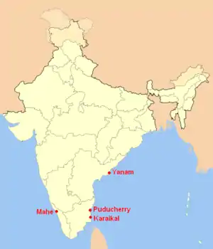
Le territoire de Pondichéry sur la carte de l'Inde.
Liste des districts
| Code[2] | District | Chef-lieu | Population (2011)[1] |
Superficie (km²) |
Densité (/km²)[1] |
Site web officiel |
| KA | Karaikal | Karaikal | 200 314 | 160 | 1 252 | http://Karaikal.gov.in/ |
| MA | Mahé | Mahé | 41 934 | 9 | 4 659 | http://mahe.gov.in/ |
| PO | Pondichéry | Pondichéry | 946 600 | 293 | 3 231 | « http://puducherry.nic.in/ »(Archive.org • Wikiwix • Archive.is • Google • Que faire ?) |
| YA | Yanam | Yanam | 55 616 | 17 | 3 272 | http://yanam.nic.in/ |
Notes et références
- (en) « Districts of Puducherry », Gouvernement de l'Inde (consulté le )
- (en) « NIC Policy on format of e-mail Address: Appendix (2): Districts Abbreviations as per ISO 3166–2 », Ministry of Communications and Information Technology, Government of India, (consulté le ), p. 5–10
Voir aussi
Cet article est issu de wikipedia. Text licence: CC BY-SA 4.0, Des conditions supplémentaires peuvent s’appliquer aux fichiers multimédias.