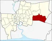
Lat Krabang
Lat Krabang est l’un des 50 khets de Bangkok, Thaïlande.
Lat Krabang
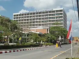
King Mongkut's Institute of Technology Lat Krabang (KMITL)
| Nom officiel |
(th) เขตลาดกระบัง |
|---|---|
| Nom local |
(th) เขตลาดกระบัง |
| Population |
168 309 hab. () |
|---|---|
| Densité |
1 358,9 hab./km2 () |
| Statut |
District de Bangkok (d) |
|---|
| Devise |
En thaï : "ลาดกระบัง" อุดมคลอง ทำเลทองการเกษตร เขตนิคม ชมตลาดโบราณหัวตะเข้ เสน่ห์วิศวกรรมเจ้าคุณทหาร สืบสานประเพณีตักบาตรพระร้อยทางเรือ รถไฟฟ้าเชื่อมสุวรรณภูมิ |
|---|
| Code postal |
10520 |
|---|---|
| Site web |

Points d'intérêt
- King Mongkut's Institute of Technology Lat Krabang (KMITL)[1]
Voir aussi
Notes et références
- (en) Erich Parpart, « Learning with the best », sur bangkokpost.com, Bangkok Post,
Liens externes
Cet article est issu de wikipedia. Text licence: CC BY-SA 4.0, Des conditions supplémentaires peuvent s’appliquer aux fichiers multimédias.