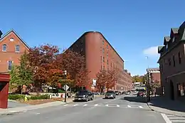
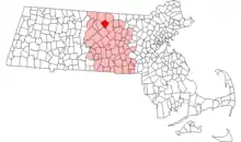
Gardner (Massachusetts)
Gardner est une ville du comté de Worcester (Massachusetts), aux États-Unis. On y compte 20 228 habitants d'après le recensement des États-Unis de 2010.
Gardner


| Pays | |
|---|---|
| État | |
| Comté | |
| Partie de | |
| Superficie |
59,64 km2 () |
| Surface en eau |
4,1 % |
| Altitude |
324 m |
| Coordonnées |
42° 34′ 30″ N, 71° 59′ 55″ O |

| Population |
21 287 hab. () |
|---|---|
| Densité |
356,9 hab./km2 () |
| Statut |
|---|
| Origine du nom |
Thomas Gardner (en) |
|---|---|
| Fondation |
| Code postal |
01440 |
|---|---|
| Code FIPS |
25-25485 |
| GNIS | |
| Site web |
(en) www.gardner-ma.gov |

Histoire
La ville est nommée en l'honneur de Thomas Gardner (en)[1]. Les premiers colons s'installent en 1764 et la localité est officiellement incorporée en 1785[2].
Démographie
| Évolution de la population | ||
|---|---|---|
| Année | Pop. | ±% |
| 1790 | 531 | — |
| 1800 | 667 | +25.6% |
| 1810 | 815 | +22.2% |
| 1820 | 911 | +11.8% |
| 1830 | 1 023 | +12.3% |
| 1840 | 1 260 | +23.2% |
| 1850 | 1 533 | +21.7% |
| 1860 | 2 646 | +72.6% |
| 1870 | 3 333 | +26.0% |
| 1880 | 4 988 | +49.7% |
| 1890 | 3 424 | −31.4% |
| 1900 | 10 813 | +215.8% |
| 1910 | 14 699 | +35.9% |
| 1920 | 16 971 | +15.5% |
| 1930 | 19 399 | +14.3% |
| 1940 | 20 206 | +4.2% |
| 1950 | 19 581 | −3.1% |
| 1960 | 19 038 | −2.8% |
| 1970 | 19 748 | +3.7% |
| 1980 | 17 900 | −9.4% |
| 1990 | 20 125 | +12.4% |
| 2000 | 20 770 | +3.2% |
| 2010 | 20 228 | −2.6% |
| 2016 | 20 430 | +1.0% |
| * = estimations. Sources : United States Census et Population Estimates Program (en)[3] - [4] - [5] - [6] - [7] - [8] - [9] - [10] - [11] - [12] - [13] Source : | ||
| Groupe | Gardner | ||
|---|---|---|---|
| Blancs | 91,4 | 80,4 | 72,4 |
| Afro-Américains | 2,8 | 6,6 | 12,6 |
| Métis | 2,2 | 2,6 | 2,9 |
| Autres | 1,7 | 4,7 | 6,4 |
| Asiatiques | 1,4 | 5,3 | 4,8 |
| Amérindiens | 0,3 | 0,3 | 0,9 |
| Total | 100 | 100 | 100 |
| Latino-Américains | 7,1 | 9,6 | 16,7 |
Selon l'American Community Survey, pour la période 2011-2015, 89,51 % de la population âgée de plus de 5 ans déclare parler anglais à la maison, alors que 5,61 % déclare parler l'espagnol, 2,79 % le français et 2,09 % une autre langue[17].
Notes et références
- (en) Cet article est partiellement ou en totalité issu de l’article de Wikipédia en anglais intitulé « Gardner, Massachusetts » (voir la liste des auteurs).
- (en) Gannett, Henry, The Origin of Certain Place Names in the United States, Govt. Print. Off., , 134 p. (lire en ligne)
- (en)Glazier, Lewis (1860).
 History of Gardner, Massachusetts: from its earliest settlement to 1860. Worcester: Chas. Hamilton. Wikisource.
 - (en) « Total Population (P1), 2010 Census Summary File 1 », American FactFinder, All County Subdivisions within Massachusetts, United States Census Bureau,
- (en) « Massachusetts by Place and County Subdivision - GCT-T1. Population Estimates », United States Census Bureau (consulté le )
- (en) « 1990 Census of Population, General Population Characteristics: Massachusetts », US Census Bureau, (consulté le ), Table 76: General Characteristics of Persons, Households, and Families: 1990
- (en) « 1980 Census of the Population, Number of Inhabitants: Massachusetts », US Census Bureau, (consulté le ), Table 4. Populations of County Subdivisions: 1960 to 1980
- (en) « 1950 Census of Population », Bureau of the Census, (consulté le ), Section 6, Pages 21-10 and 21-11, Massachusetts Table 6. Population of Counties by Minor Civil Divisions: 1930 to 1950
- (en) « 1920 Census of Population », Bureau of the Census (consulté le ), Number of Inhabitants, by Counties and Minor Civil Divisions. Pages 21-5 through 21-7. Massachusetts Table 2. Population of Counties by Minor Civil Divisions: 1920, 1910, and 1920
- (en) « 1890 Census of the Population », Department of the Interior, Census Office (consulté le ), Pages 179 through 182. Massachusetts Table 5. Population of States and Territories by Minor Civil Divisions: 1880 and 1890
- (en) « 1870 Census of the Population », Department of the Interior, Census Office, (consulté le ), Pages 217 through 220. Table IX. Population of Minor Civil Divisions, &c. Massachusetts
- (en) « 1860 Census », Department of the Interior, Census Office, (consulté le ), Pages 220 through 226. State of Massachusetts Table No. 3. Populations of Cities, Towns, &c.
- (en) « 1850 Census », Department of the Interior, Census Office, (consulté le ), Pages 338 through 393. Populations of Cities, Towns, &c.
- (en) « 1950 Census of Population », Bureau of the Census, vol. 1: Number of Inhabitants, , Section 6, Pages 21-7 through 21-09, Massachusetts Table 4. Population of Urban Places of 10,000 or more from Earliest Census to 1920 (lire en ligne, consulté le )
- (en) « Census of Population and Housing » [archive du ], Census.gov (consulté le )
- (en) « Profile of General Population and Housing Characteristics: 2010 », sur factfinder.census.gov (consulté le )
- (en) « Population of Massachusetts - Census 2010 and 2000 », sur censusviewer.com.
- (en) « Language spoken at home by ability to speak English for the population 5 years and over », sur factfinder.census.gov.
Liens externes
- (en) Site officiel
- Ressource relative à la géographie :
Cet article est issu de wikipedia. Text licence: CC BY-SA 4.0, Des conditions supplémentaires peuvent s’appliquer aux fichiers multimédias.