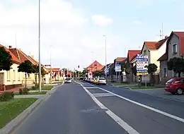
Dolní Měcholupy
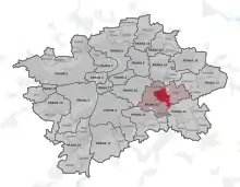
Dolní Měcholupy (en allemand Unter Miecholup) est un quartier pragois situé dans l'est de la capitale tchèque, appartenant à l'arrondissement de Prague 10, d'une superficie de 466,0 hectares est un quartier de Prague. En 2018, la population était de 3 147 habitants[1].
Dolní Měcholupy


| Nom officiel |
(cs) Dolní Měcholupy |
|---|
| Pays | |
|---|---|
| Capitale | |
| District territorial |
Prague 10 (d) |
| District administratif | |
| District administratif |
Prague 15 (d) |
| Superficie |
4,66 km2 |
| Coordonnées |
50° 03′ 32″ N, 14° 33′ 29″ E |
| Population |
4 132 hab. () |
|---|---|
| Densité |
886,7 hab./km2 () |
| Statut |
|---|

La première mention écrite de Dolní Měcholupy date du 1293. La ville est devenue une partie de Prague en 1968.
Notes et références
- « Obyvatelstvo a rozloha katastrálních území Prahy 2001–2018 », Czech Statistical Office,
Liens externes
Cet article est issu de wikipedia. Text licence: CC BY-SA 4.0, Des conditions supplémentaires peuvent s’appliquer aux fichiers multimédias.