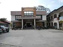
Aringay
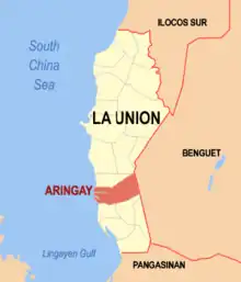
Aringay est une localité de la province de La Union, aux Philippines. En 2015, elle compte 47 458 habitants.
Aringay

| Nom officiel |
(en) Municipality of Aringay |
|---|
| Pays | |
|---|---|
| Région | |
| Province | |
| Superficie |
84,54 km2 |
| Altitude |
38 m |
| Coordonnées |
16° 23′ 54″ N, 120° 21′ 20″ E |
| Population |
50 380 hab. () |
|---|---|
| Densité |
595,9 hab./km2 () |
| Statut |
|---|
| Fondation |
|---|
| Code postal |
2503 |
|---|---|
| Indicatif téléphonique |
72 |
| Site web |

Démographie
| Recensement de la population de Aringay | ||
|---|---|---|
| Année | Pop. | ±% p.a. |
| 1903 | 8 572 | — |
| 1918 | 11 247 | +1.83% |
| 1939 | 12 487 | +0.50% |
| 1948 | 13 079 | +0.52% |
| 1960 | 17 572 | +2.49% |
| 1970 | 21 835 | +2.19% |
| 1975 | 25 042 | +2.79% |
| 1980 | 27 524 | +1.91% |
| 1990 | 33 258 | +1.91% |
| 1995 | 36 743 | +1.88% |
| 2000 | 41 422 | +2.60% |
| 2007 | 43 438 | +0.66% |
| 2010 | 44 949 | +1.25% |
| 2015 | 47 458 | +1.04% |
| Source : Philippine Statistics Authority[1] - [2] - [3] - [4] | ||
Notes et références
- (en) Cet article est partiellement ou en totalité issu de l’article de Wikipédia en anglais intitulé « Aringay » (voir la liste des auteurs).
- (en) Census of Population (2015), « Total Population by Province, City, Municipality and Barangay », dans Census of Population (2015), Total Population by Province, City, Municipality and Barangay, « Region I (Ilocos Region) » (consulté le )
- (en) Census of Population and Housing (2010), « Total Population by Province, City, Municipality and Barangay », dans Census of Population and Housing (2010), Total Population by Province, City, Municipality and Barangay, « Region I (Ilocos Region) » (consulté le )
- (en) Census of Population (1995, 2000 and 2007), « Total Population by Province, City and Municipality », dans Census of Population (1995, 2000 and 2007), Total Population by Province, City and Municipality (lire en ligne [archive du ]), « Region I (Ilocos Region) »
- (en) Municipality Population Data, « Province de La Union », Local Water Utilities Administration (en) Research Division (consulté le )
Cet article est issu de wikipedia. Text licence: CC BY-SA 4.0, Des conditions supplémentaires peuvent s’appliquer aux fichiers multimédias.